South Australian Current Regulations South Australian Current Regulations
112—Emergency position indicating radio beacons (EPIRBs)
(1) For the purposes
of section 65A(1) of the Act, the following classes of vessels are
specified:
(a)
canoes, kayaks, rowboats or other similar small human-powered recreational
vessels being operated in unprotected waters;
(b) all
other vessels being operated in prescribed unprotected waters.
(2) However, a canoe,
kayak, rowboat or other similar small human-powered recreational vessel being
operated in unprotected waters is exempt from the requirement to carry an
EPIRB if—
(a) the
vessel is in the company of—
(i)
at least 2 similar vessels; or
(ii)
a support vessel; and
(b) at
least 1 of the other vessels referred to in paragraph (a) is equipped
with an EPIRB; and
(c) the
vessel remains within 50 m of the vessel so equipped at all times.
(3) For the purposes
of section 65A(1) of the Act, the following requirements relating to
emergency position indicating radio beacons are specified:
(a) the
beacon must be capable of transmitting on a frequency of 406 megahertz;
(b) the
beacon must comply with AS/NZS 4280.1:2022: 406 MHz satellite distress
beacons - Marine emergency position-indicating radio beacons (EPIRBs) ;
(c) the
beacon must be currently registered with the Australian Maritime Safety
Authority;
Editorial note—
The procedures for obtaining and renewing registration of EPIRBs as required
by this regulation are set out by the Australian Maritime Safety Authority.
(d) the
beacon must be suitably located and secured on the relevant vessel having
regard to the need for access to the beacon and the need to protect the beacon
from accidental damage or loss;
(e) the
beacon must be maintained in good working order.
"coast" means—
(a) the
coast of the mainland; and
(b) the
coast of Kangaroo Island;
"prescribed unprotected waters" means—
(a)
those unprotected waters more than 5 nautical miles seaward of the Low
Water Mark of the coast in the waters of Spencer Gulf or Gulf St. Vincent; or
(b)
those unprotected waters more than 3 nautical miles seaward of the Low
Water Mark of the coast in the waters of any other area except Lakes
Alexandrina and Albert;
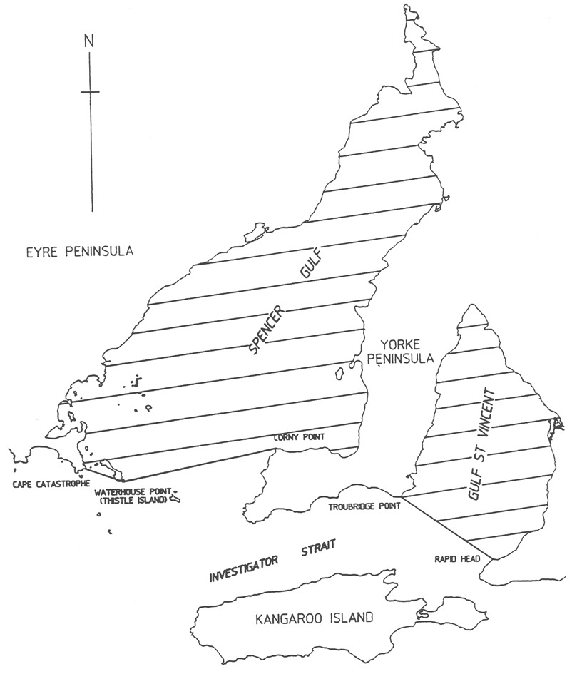
"waters of Spencer Gulf or Gulf St. Vincent" means—
(a) for
Spencer Gulf—the waters in that gulf north of a line drawn from Cape
Catastrophe on Eyre Peninsula to Waterhouse Point on Thistle Island and then
to Corny Point on Yorke Peninsula (see following map);
(b) for
Gulf St. Vincent—the waters in that gulf north of a line drawn from
Troubridge Point on Yorke Peninsula to Rapid Head on Fleurieu Peninsula (see
following map).
Editorial Note—
The following map is provided for convenience of reference only.
Waters of Spencer Gulf and Gulf St. Vincent