South Australian Current Regulations South Australian Current Regulations
Schedule 3—Definition of harbor boundaries
Editorial note—
Unless the contrary intention appears, the maps in this Schedule are provided
for convenience of reference only.
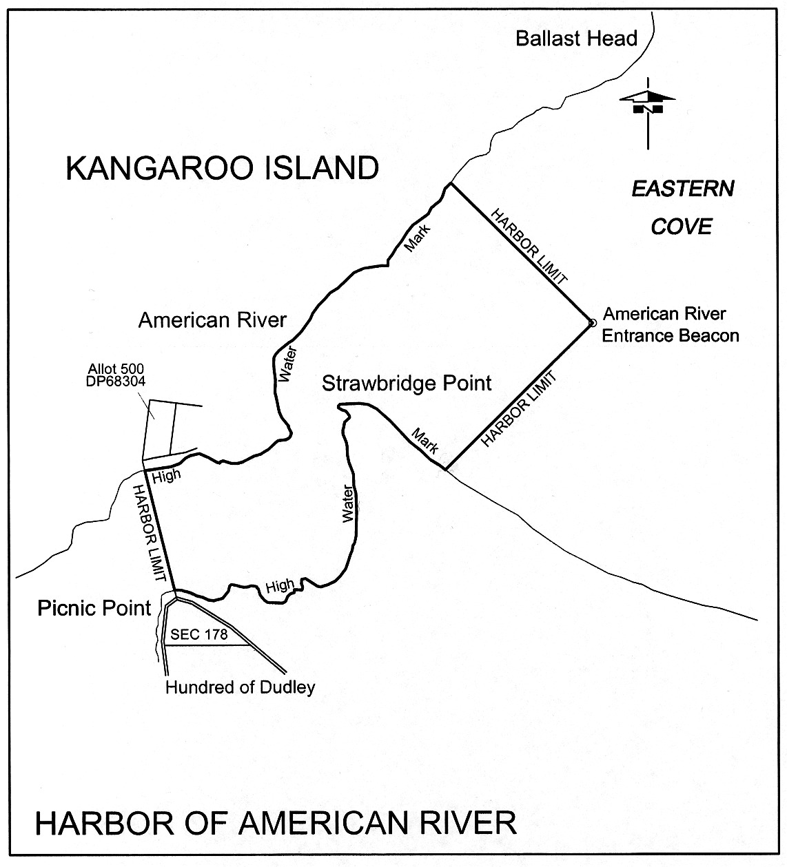
American River
The subjacent land underlying, and the adjacent land extending from, the
waters, rivers, creeks, and inlets to the High Water Mark of American River
and Eastern Cove bounded as follows:
on the north by a line running north-west from the American River Entrance
Beacon to intersect with the High Water Mark on the western side of Eastern
Cove then generally south-west along the High Water Mark to its intersection
with a straight line drawn from the south-west corner of Allotment 500 in
Deposited Plan No 68304 to the most northerly point of Section 178,
Hundred of Dudley; then south-easterly along the line to its intersection with
the High Water Mark; then generally easterly and northerly along the High
Water Mark on the eastern side of American River to Strawbridge Point, then
easterly along the High Water Mark to its intersection with a line running
south-west from the Entrance Beacon, then along this line to the point of
commencement.
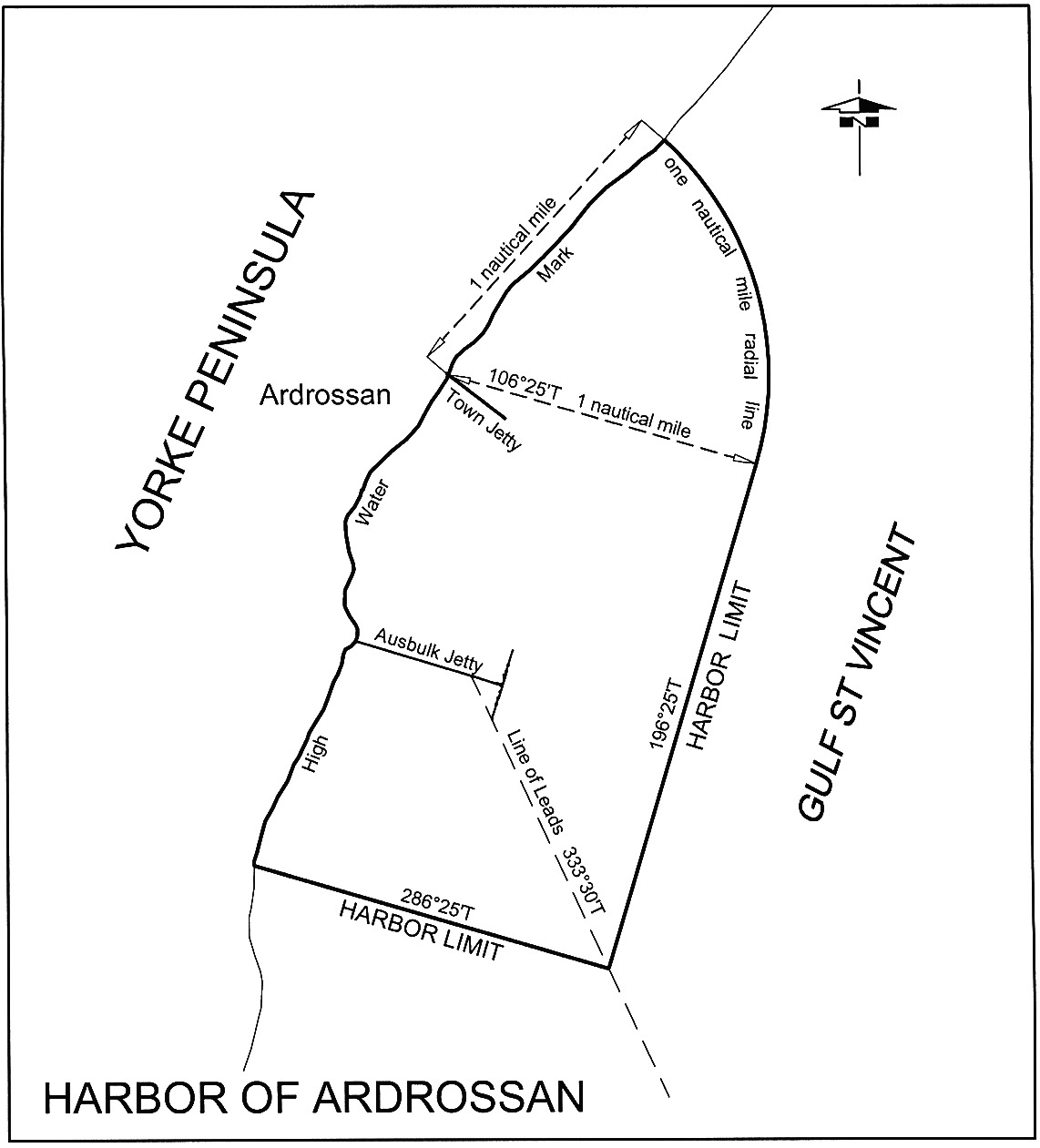
Ardrossan
The subjacent land underlying, and adjacent land extending from, the waters,
rivers, creeks and inlets to the High Water Mark of that portion of the
western coast of Gulf St. Vincent bounded as follows:
commencing at a point on a line bearing 106°25′ True and
distance 1 nautical mile from the intersection of the centre line of the
Ardrossan town jetty and the High Water Mark; then by a line
bearing 196°25′ True to its intersection with the Ausbulk
Jetty line of leads bearing 333°30′ True; then by a line
bearing 286°25′ True to its intersection with the High
Water Mark; then generally north-north-easterly along the High Water Mark to a
point distant 1 nautical mile north-north-easterly and radial from the
intersection of the High Water Mark and centre line of the Ardrossan town
jetty; then by a 1 nautical mile radial line to the point of
commencement.
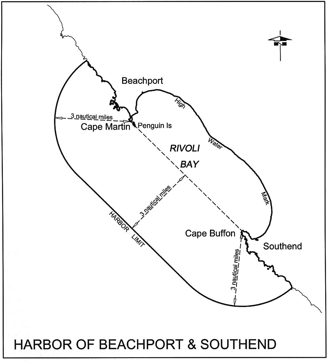
Beachport and Southend
The subjacent land underlying, and the adjacent land extending from, the
waters, rivers, creeks and inlets to the High Water Mark on the coast within
3 nautical miles from any point on a straight line between Cape Martin
and Cape Buffon.
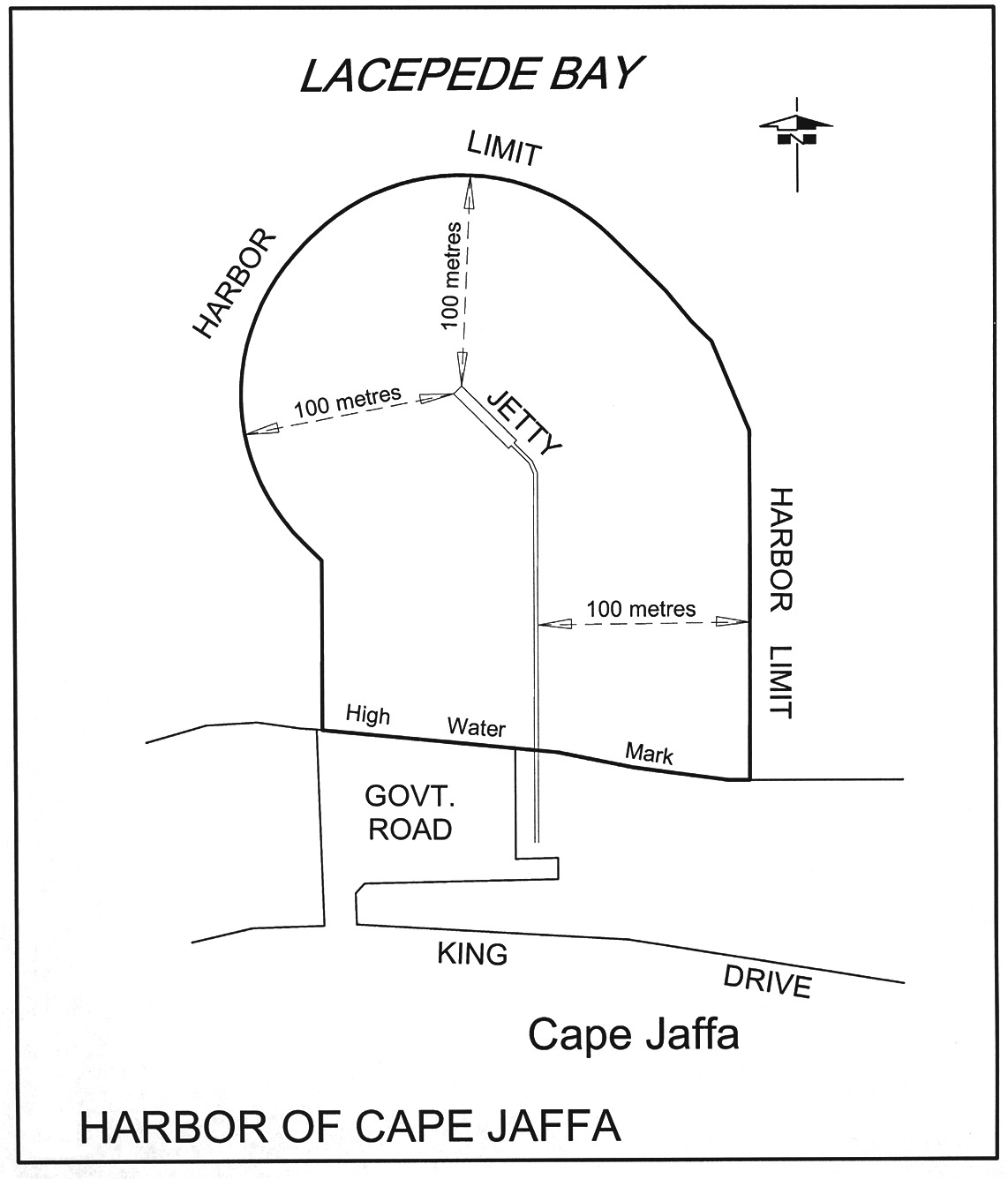
Cape Jaffa
The subjacent land underlying, and the adjacent land extending from, the
waters, rivers, creeks and inlets to the High Water Mark within 100 m
seaward of any part of the Cape Jaffa Jetty.
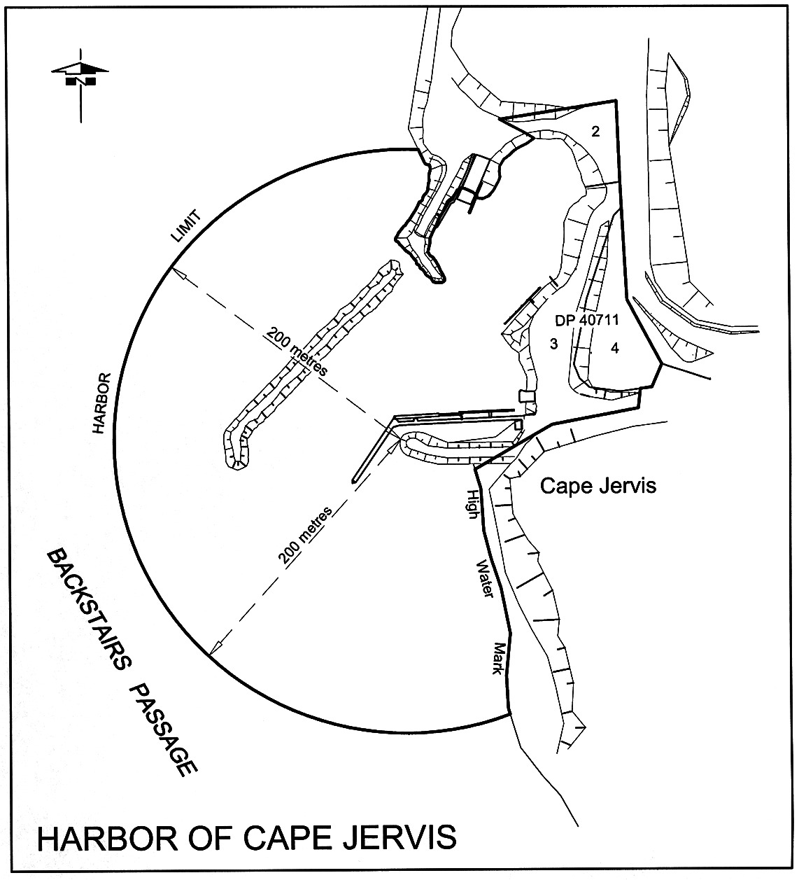
Cape Jervis
The following areas:
(a) the
subjacent land underlying, and the adjacent land extending from, the waters,
rivers, creeks and inlets to the High Water Mark within a distance of
200 m from the western tip of the south-eastern breakwater at Cape
Jervis;
(b)
allotments 2, 3 and 4 of Deposited Plan No 40711.
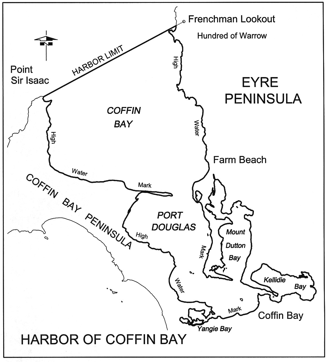
Coffin Bay
The subjacent land underlying, and the adjacent land extending from, the
waters, rivers, creeks and inlets to the High Water Mark of Coffin Bay, Port
Douglas, Mount Dutton Bay and Kellidie Bay, contained within a line drawn from
Point Sir Isaac to a hill known as "Frenchman Lookout" in the Hundred of
Warrow.
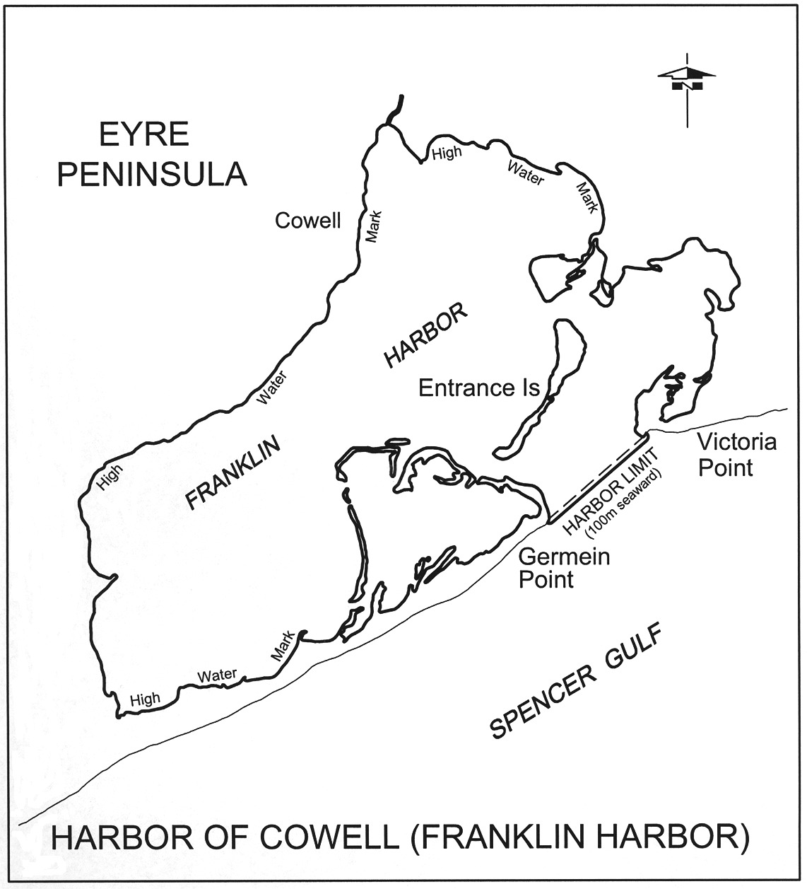
Cowell (Franklin Harbor)
The subjacent land underlying, and the adjacent land extending from, the
waters, rivers, creeks and inlets to the High Water Mark of Franklin Harbor
and within a straight line from Germein Point to Victoria Point, and
100 m to seaward of any point on that line.
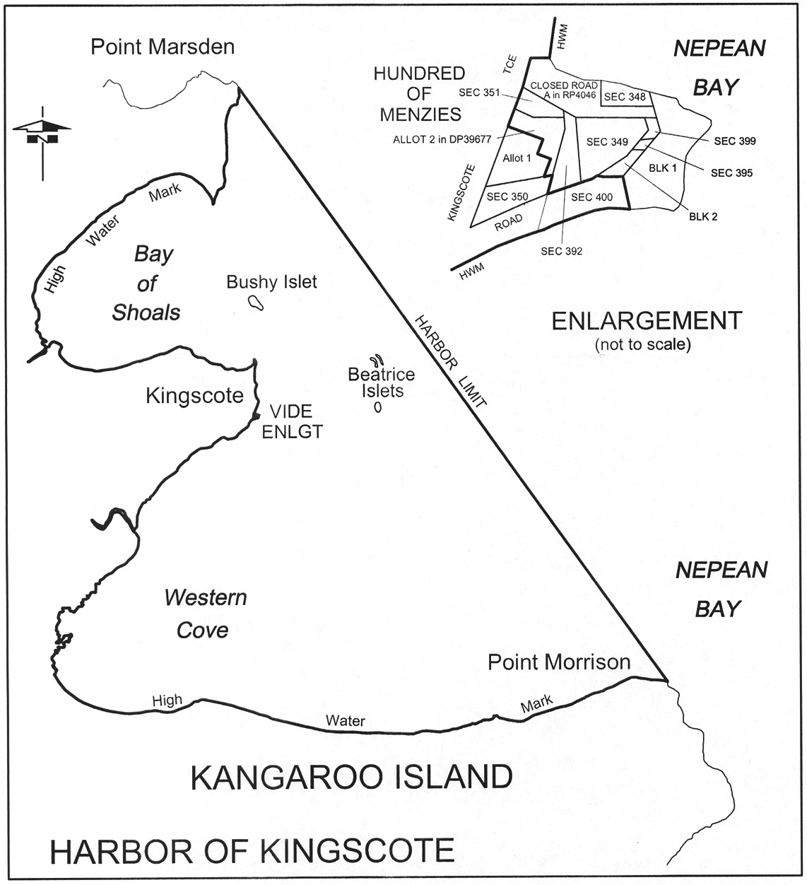
Kingscote
The following areas:
(a) the
subjacent land underlying, and the adjacent land extending from, waters,
rivers, creeks and inlets to the High Water Mark in Nepean Bay, Kangaroo
Island and west of a straight line from Point Marsden to Point Morrison;
(b) the
following parcels of land:
•
Sections 351, 348, 349, 392, 395, 399 and Blocks 1 and 2 in the
Hundred of Menzies
•
Allotment 2 in Deposited Plan No 39677
• Closed Road A
in Road Plan 4046.
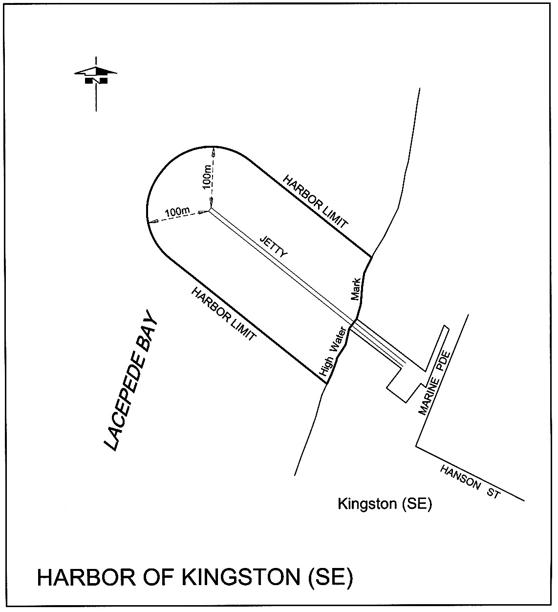
Kingston (SE)
The subjacent land underlying, and the adjacent land extending from, the
waters, rivers, creeks and inlets to the High Water Mark within 100 m
seaward of any part of the Kingston Jetty.
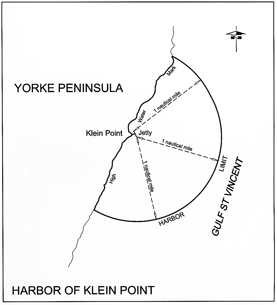
Klein Point
The subjacent land underlying, and the adjacent land extending from, the
waters, rivers, creeks and inlets to the High Water Mark within
1 nautical mile seaward of any part of the Klein Point Jetty.
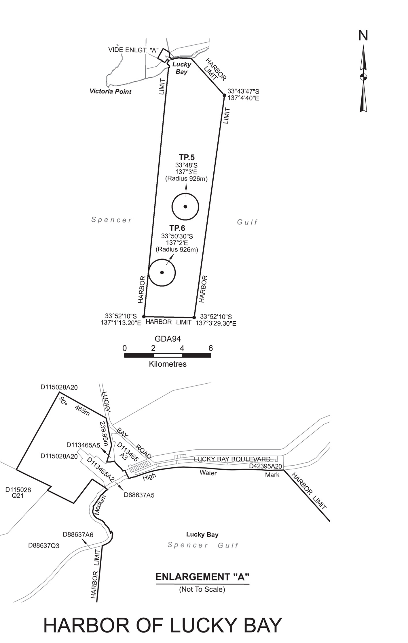
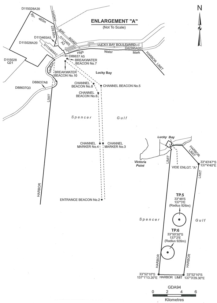
Lucky Bay
The area bounded as follows:
commencing at a point (being the northernmost
corner of the Lucky Bay Harbor) situated on the north-eastern boundary of
Allotment 1 in Deposited Plan 113465 being the back bearing of
299°14′40″ from the intersection of the western boundary of
Lucky Bay Road and the southernmost corner of Piece 13 in Deposited
Plan 94729 for a distance of 465 m, then south-easterly on a bearing
of 119°14′40″ for a distance of 465 m to the western
boundary of Lucky Bay Road, then southerly on a bearing of
168°27′20″ along the western boundary of Lucky Bay Road and
its production along an eastern boundary of Allotment 20 in Deposited
Plan 115028 for a distance of 239.95 m, then southerly on a bearing
of 195°57′50″ for a distance of 153.18 m, then easterly
on a bearing of 88°06′00" for a distance of 30.66 m, then
easterly on a bearing of 78°50′00" for a distance of 35 m,
then easterly on a bearing of 100°46′00" for a distance of
3.25 m, then south-easterly on a bearing of 150°10′30″
for a distance of 7.5 m, then south-easterly on a bearing of
140°07′30″ for a distance of 44 m, then south-easterly
on a bearing of 120°29′30″ for a distance of 13 m, then
south-easterly on a bearing of 136°20′30″ for a distance of
27 m, then south-easterly on a bearing of 150°45′30″ for
a distance of 21 m, then north-easterly on a bearing of
65°03′30″ for a distance of 15.02 m, then south-easterly on a
bearing of 152°42′10″ for a distance of approximately
86 m to the Medium High Water Mark, then easterly along the Medium High
Water Mark to a point being the production southerly of the eastern boundary
of Allotment 20 in Deposited Plan 42395 to the intersection of the
said Medium High Water Mark, then south-easterly along the Harbor Limit
boundary to a point being at Longitude 137°4′40″ East and
Latitude 33°43′47″ South, then southerly along the eastern
Harbor Limit boundary to a point being at Longitude
137°3′29.30″ East and Latitude 33°52′10″
South, then westerly along the southern Harbor Limit boundary to a point being
at Longitude 137°1′13.20″ East and Latitude
33°52′10″ South, then northerly along the western Harbor
Limit boundary to a point on the Medium High Water Mark being the intersection
of an arbitrary straight line from Longitude 137°1′13.20″
East and Latitude 33°52′10″ South to the southernmost corner
of Allotment 5 in Deposited Plan 88637, then generally northerly
along the Medium High Water Mark to the southernmost corner of
Allotment 5 in Deposited Plan 88637, then north-westerly on a
bearing of 307°41′30″ for a distance of approximately
157.6 m, then south-westerly on a bearing of 217°41′30″
for a distance of 265 m, then north-westerly on a bearing of
296°20′00" for a distance of 254.08 m to the eastern boundary
of Piece 21 in Deposited Plan 115028, then north-easterly on a
bearing of 43°01′40″ for a distance of 57.54 m, then
north-westerly on a bearing of 296°14′20″ to a point on a
southern boundary of Allotment 20 in Deposited Plan 115028 being the
intersection of an arbitrary straight line heading in a south-westerly
direction with an internal angle of 90° from the point of commencement to
the said intersection, then north-easterly from the said intersection back to
the point of commencement.
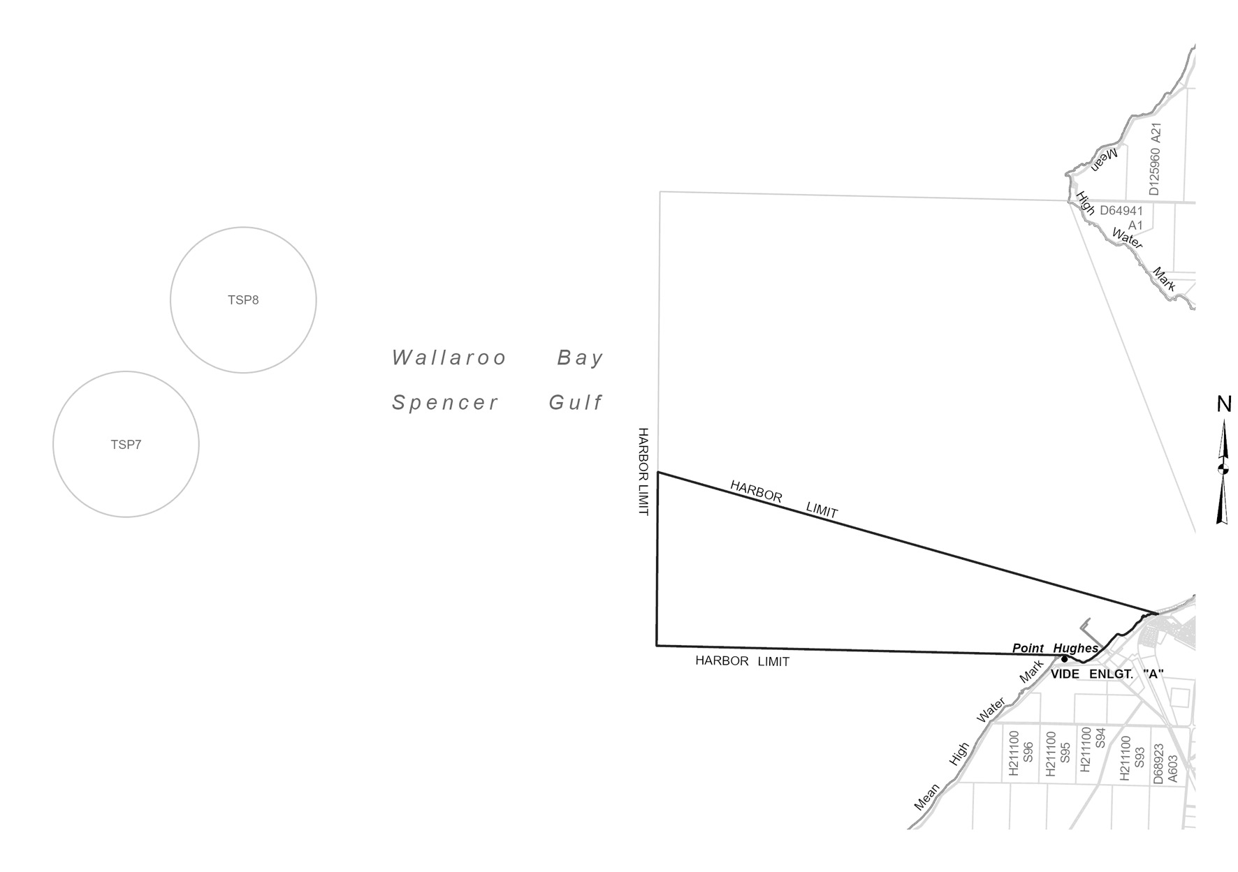
Narungga
The subjacent land underlying, and the adjacent land extending from, the
waters, rivers, creeks and inlets to the High Water Mark of that part of
Wallaroo Bay bounded as follows:
commencing at a point on the High Water Mark at longitude
137°36’04.71" East and the northern extremity of Point Hughes, then
westerly for 3 nautical miles to latitude 33°56'07.41" South, longitude
137°32'30.69" East, then northerly to latitude 33°54'50.72" South,
longitude 137°32'29.20" East, then generally south easterly for 3.8
nautical miles to a point on the High Water Mark at longitude
137°36'55.68" East, then generally south westerly along the High Water
Mark back to the point of commencement.
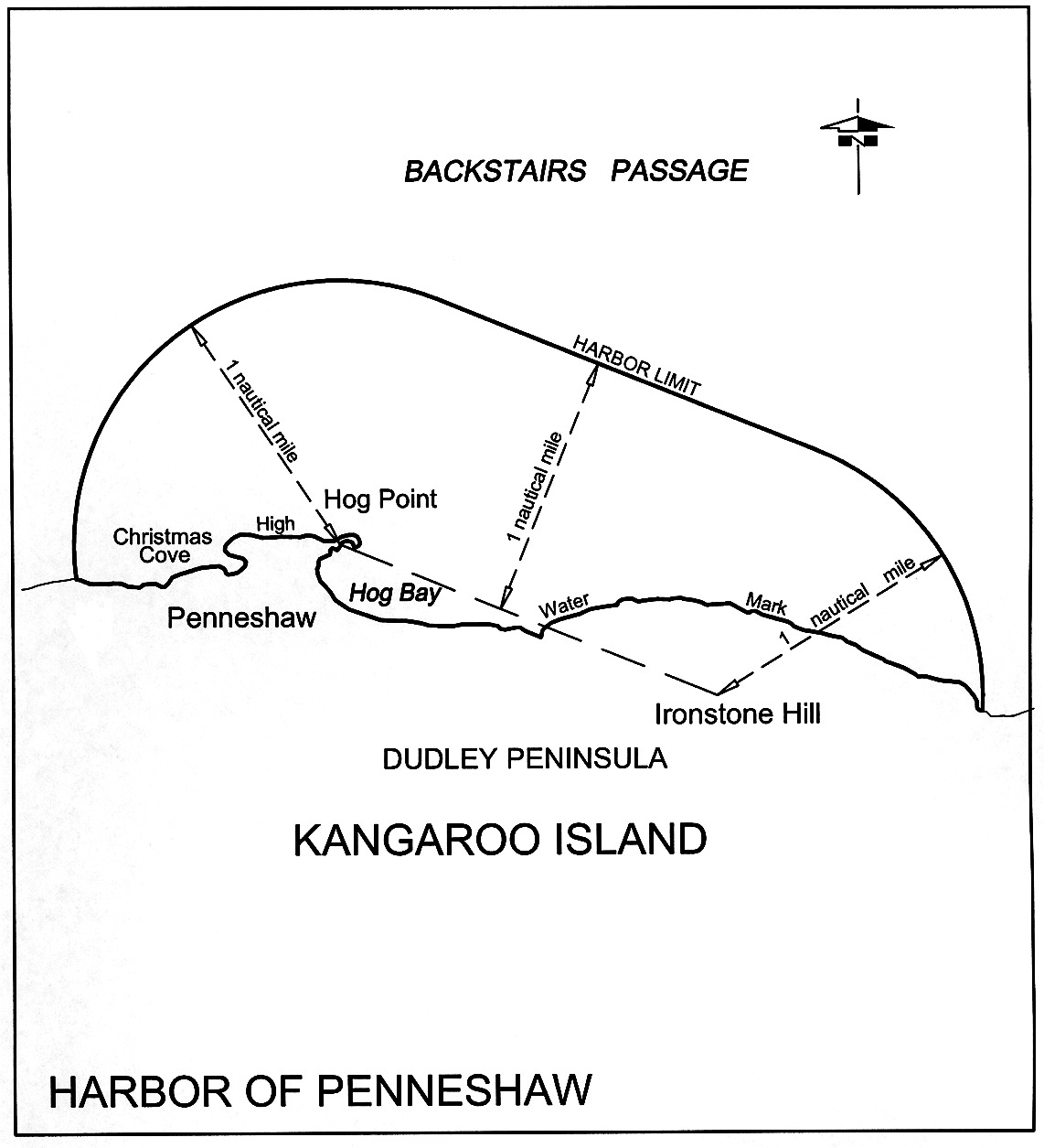
Penneshaw
The subjacent land underlying, and the adjacent land extending from, the
waters, rivers, creeks and inlets to the High Water Mark on the northern coast
of Dudley Peninsula, Kangaroo Island, and within a straight line from Hog
Point to Ironstone Hill, and 1 nautical mile to seaward from any point on
that line.
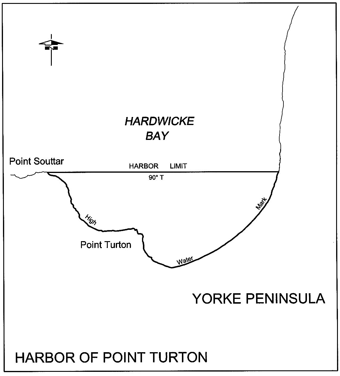
Point Turton
The subjacent land underlying, and the adjacent land extending from, the
waters, rivers, creeks and inlets to the High Water Mark on the southern shore
of Hardwicke Bay, bounded as follows:
commencing at Point Souttar; then true east to the High Water Mark on the sea
coast; then south-westerly and north-westerly following the High Water Mark to
the point of commencement.
Port Adelaide
(1) The following
areas:
(a) the
subjacent land underlying, and the adjacent land extending from, the waters,
rivers, creeks and inlets to the High Water Mark bounded as follows:
(i)
on the north by a line extending due west for
5 nautical miles from a point on the Low Water Mark being the
north-western corner of the Hundred of Port Adelaide (approximate
latitude 34°40.42′S);
(ii)
on the south by a line extending due west for
5 nautical miles from a point on the Low Water Mark being the
south-western corner of the Hundred of Port Adelaide (approximate
latitude 34°51.30′S);
(iii)
on the west by a line extending north-north-westerly and
connecting the western extremities of the southern and northern boundaries;
but excluding—
(iv)
the area bounded on the south by a line being the
production west of the southern side of Section 1048, Hundred of Port
Adelaide, and on the north by a line running east and west 1 nautical
mile north of the Largs Bay Jetty, except for—
(A) a strip of land 10 m wide on each
side of the centreline of the Semaphore Jetty and extending easterly from the
Low Water Mark to the eastern end of the approach to that jetty; and
(B) a strip of land 10 m wide on each
side of the centreline of the Largs Bay Jetty and extending easterly from the
Low Water Mark to the eastern end of the approach to that jetty;
(v)
the area bounded on the south by a line running east and
west 1 nautical mile north of the Largs Bay Jetty and on the north-west
by a line extending south-westerly from the northern most corner of
Section 389, Hundred of Port Adelaide, and at right angles to the
north-eastern boundary of Section 389;
(vi)
the area bounded as follows: commencing at a point on the
northern boundary of the Hundred of Port Adelaide, being its intersection with
the western edge of the mangroves along the eastern shore of Gulf
St. Vincent, then southerly and generally south-easterly along portion of
that western edge to intersect the production south-westerly of the
north-western boundary of the road north-west of Section B, Hundred of
Port Adelaide, then north-easterly along that production and portion of
boundary to the High Water Mark, then generally north-westerly along that High
Water Mark to that northern Hundred boundary, then generally westerly along
portion of the latter boundary to the point of commencement;
(vii)
that portion of the subjacent land underlying, and the
adjacent land extending from, Old Port Reach (including Port Adelaide Canal),
Port Adelaide River, Out of Hundreds (Adelaide) to the High Water Mark bounded
as follows:
(A) on the north by a straight line between
the bend on the eastern boundary of Section 661, Hundred of Port
Adelaide, at corner 162°12′ and the bend on the western
boundary of Section 7640, Hundred of Port Adelaide at
corner 173°45′;
(B) on the south by the southern boundary
of the Hundred of Port Adelaide;
(viii)
the following parcels of land:
• Allotment 708
of Deposited Plan No 123204
• Allotment 807
of Deposited Plan No 128471;
(ix)
the following parcels of land:
• Allotment 9 of
Deposited Plan No 28523
• Allotment 40
of Deposited Plan No 133651
• Allotment 602
of Deposited Plan No 131998 to the extent it comprises subjacent land or
adjacent land to the High Water Mark
• Allotment 501
of Deposited Plan No 87145 to the extent it comprises subjacent land or
adjacent land to the High Water Mark
• Allotment 22
of Deposited Plan No 76309 to the extent it comprises subjacent land or
adjacent land to the High Water Mark;
(b) the
whole of the land comprised in Certificates of Title Register Book—
• Volume 1962
Folio 149
• Volume 1974
Folio 153
• Volume 1974
Folio 154
• Volume 2436
Folio 64
• Volume 2772
Folio 12
• Volume 3009
Folio 131
• Volume 4383
Folio 154
• Volume 5086
Folio 57
• Volume 5123
Folio 453
• Volume 5128
Folio 416
• Volume 5143
Folio 963
• Volume 5179
Folio 216
• Volume 5179
Folio 219
• Volume 5179
Folio 223
• Volume 5191
Folio 911
• Volume 5202
Folio 446
• Volume 5202
Folio 448
• Volume 5202
Folio 451
• Volume 5202
Folio 452
• Volume 5211
Folio 177;
(c) the
following parcels of land:
• Allotments 1,
2, 7, 9, 10 and 12 of Deposited Plan No 40901
• Allotments 52,
55, 57 and 58 of Deposited Plan No 41580
• Allotments 1,
2, 4, 5 and 6 of Deposited Plan No 41006
• Allotments 1,
3, 4 and 7 of Deposited Plan No 41578
• Allotments 101
and 102 of Deposited Plan No 39922
• Allotment 2 of
Deposited Plan No 31181
• Allotments 54
and 55 of Deposited Plan No 41577.
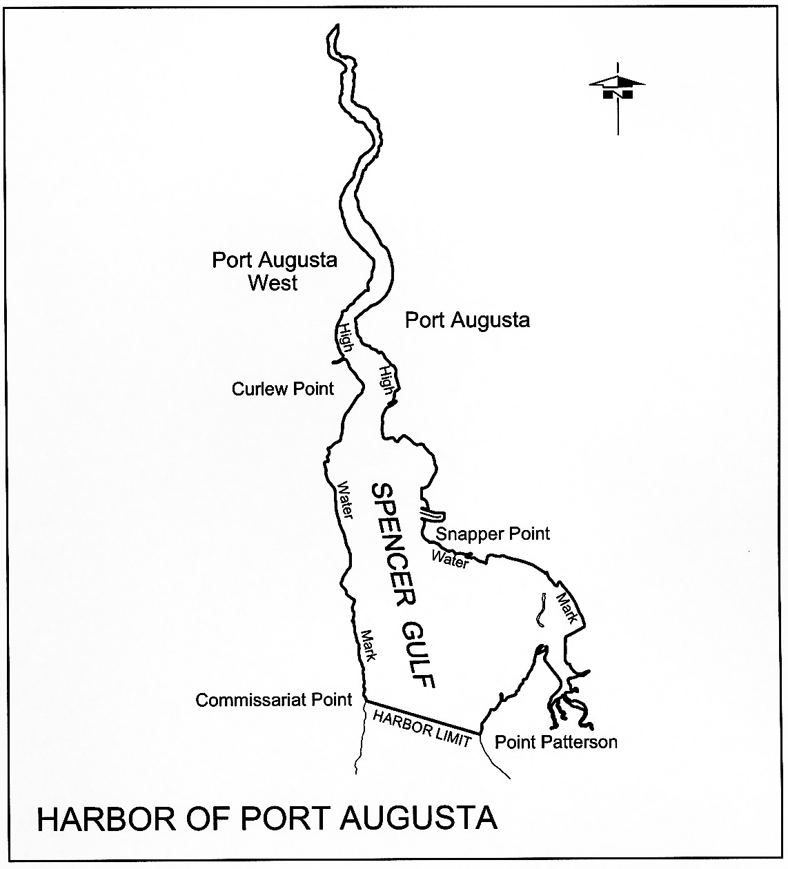
Port Augusta
The subjacent land underlying, and the adjacent land extending from, the
waters, rivers, creeks and inlets to the High Water Mark of all that portion
of Spencer Gulf, north of a line drawn across the Gulf from Point Patterson to
Commissariat Point, and including all navigable waters to the extreme northern
extent of the Gulf.
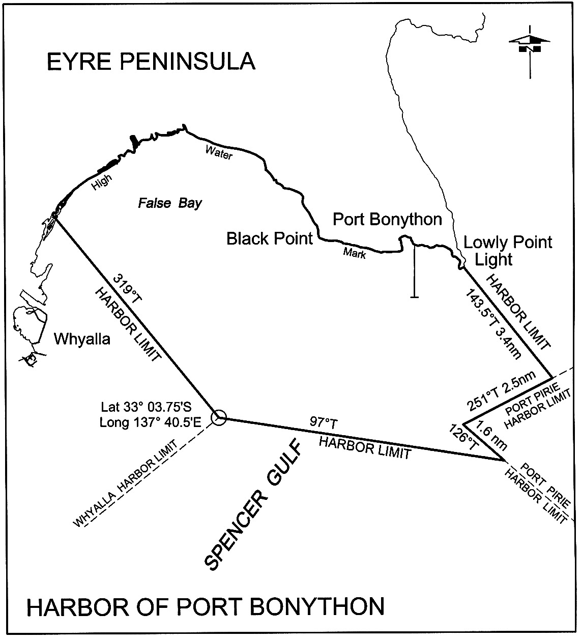
Port Bonython
The subjacent land underlying, and the adjacent land extending from, the
waters, rivers, creeks and inlets to the High Water Mark of that portion of
the western coast of Spencer Gulf bounded as follows:
commencing at the eastern extremity of the harbor of Whyalla,
latitude 33°03.75′ South,
longitude 137°40.5′ East, then along the north-east
boundary of that harbor bearing 319° True to the High Water
Mark, then generally easterly along the High Water Mark to its intersection
with a straight line bearing 143.5° True from Lowly Point
Light, then along the latter line for a distance of approximately
3.4 nautical miles to the north boundary of the harbor of Port Pirie,
then along the latter line bearing 251° True for a distance of
approximately 2.5 nautical miles to the west extremity of that harbor,
then along the south-west boundary of that harbor
bearing 126° True for a distance of approximately
1.6 nautical miles to its intersection with a straight line
bearing 97° True from the point of commencement, then along the
latter line to the point of commencement.
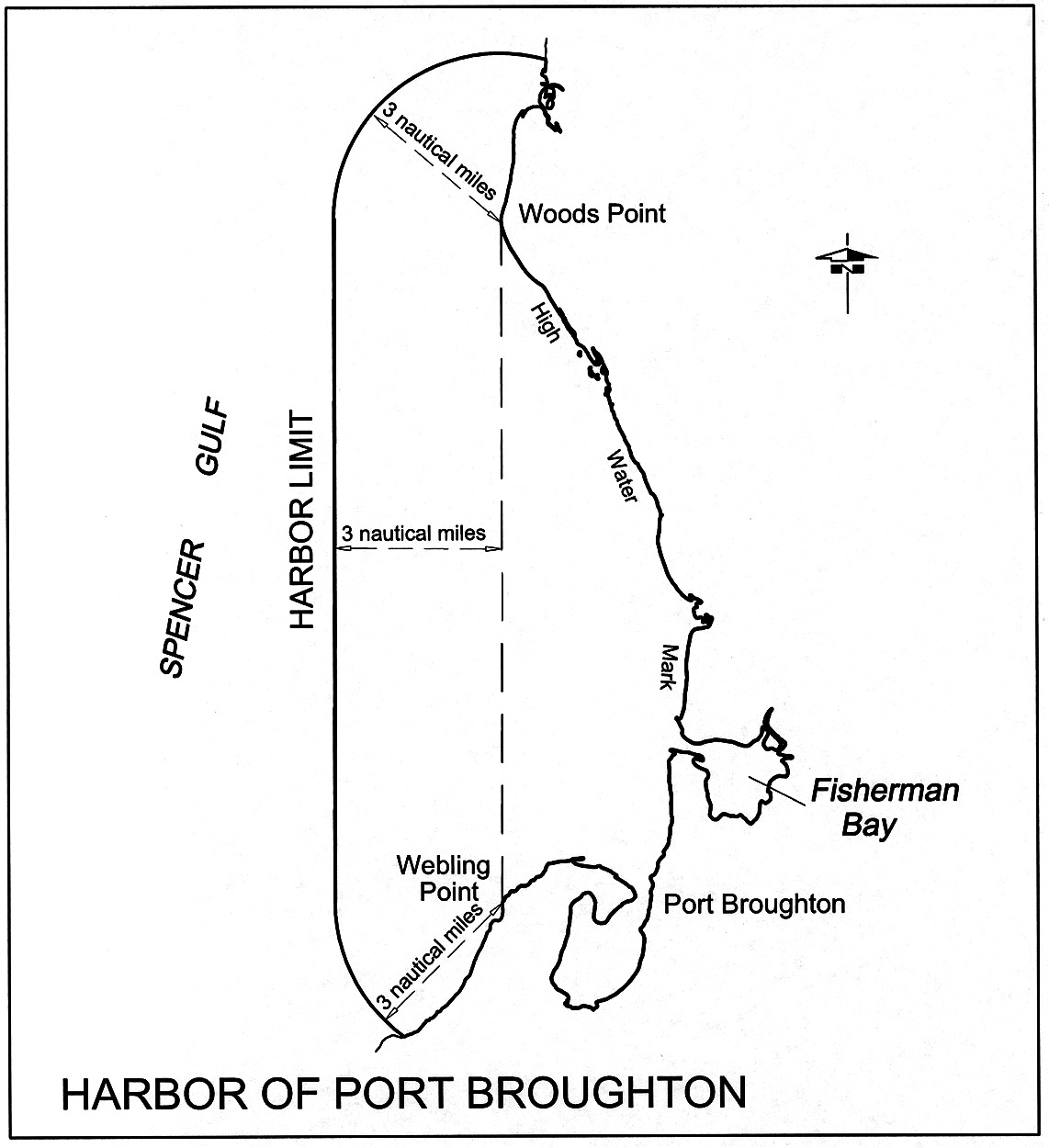
Port Broughton
The subjacent land underlying, and the adjacent land extending from, the
waters, rivers, creeks and inlets to the High Water Mark on the eastern coast
of Spencer Gulf, and within a straight line drawn from Woods Point to Webling
Point, and over 3 nautical miles to seaward measured from any point on
the line.
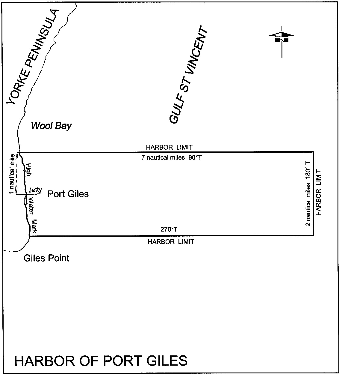
Port Giles
The subjacent land underlying, and the adjacent land extending from, the
waters, rivers, creeks and inlets to the High Water Mark of that portion of
the western coast of Gulf St. Vincent bounded as follows:
commencing at a point on the High Water Mark 1 nautical mile due north of
the intersection of the centre line of the Port Giles Jetty with the High
Water Mark; then by a line bearing due east from the High Water Mark for
7 nautical miles; then on a line bearing due south for 2 nautical
miles; then on a line bearing due west to the High Water Mark; then generally
northerly along the High Water Mark to the point of commencement.
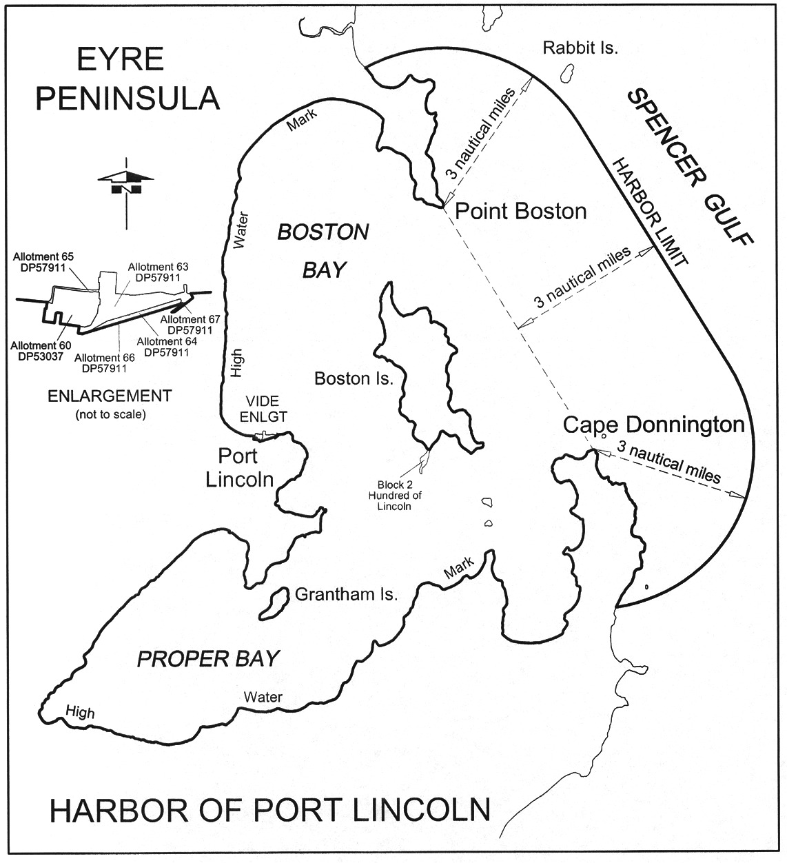
Port Lincoln
The following areas:
(a) the
subjacent land underlying, and the adjacent land extending from, the waters,
rivers, creeks and inlets to the High Water Mark of Port Lincoln, as embraced
within a straight line drawn between Cape Donnington and Point Boston, and
within 3 nautical miles to seaward, measured from any point on the line;
(b) the
following parcels of land:
• Allotments 63,
64, 65 and 66 in Deposited Plan No 57911
• Allotment 60
in Deposited Plan No 53037
• Block 2,
Hundred of Lincoln.
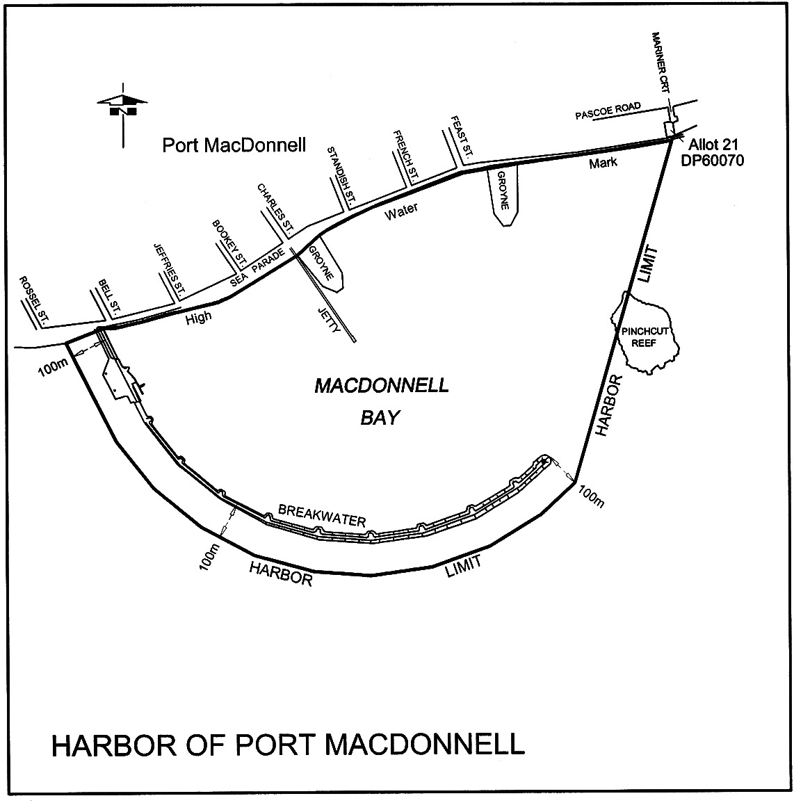
Port MacDonnell
The subjacent land underlying, and the adjacent land extending from, the
waters, rivers, creeks and inlets to the High Water Mark of that portion of
MacDonnell Bay bounded as follows:
commencing at the intersection of the High Water Mark and a line 100 m
westerly and parallel to the centre line of the breakwater, then generally
south and east along the line to a point south-west of the eastern tip of the
breakwater, then north-easterly along a line towards the south-east corner of
Allotment 21 of Deposited Plan No 60070 to its intersection with the High
Water Mark, then generally westerly along the High Water Mark to the point of
commencement.
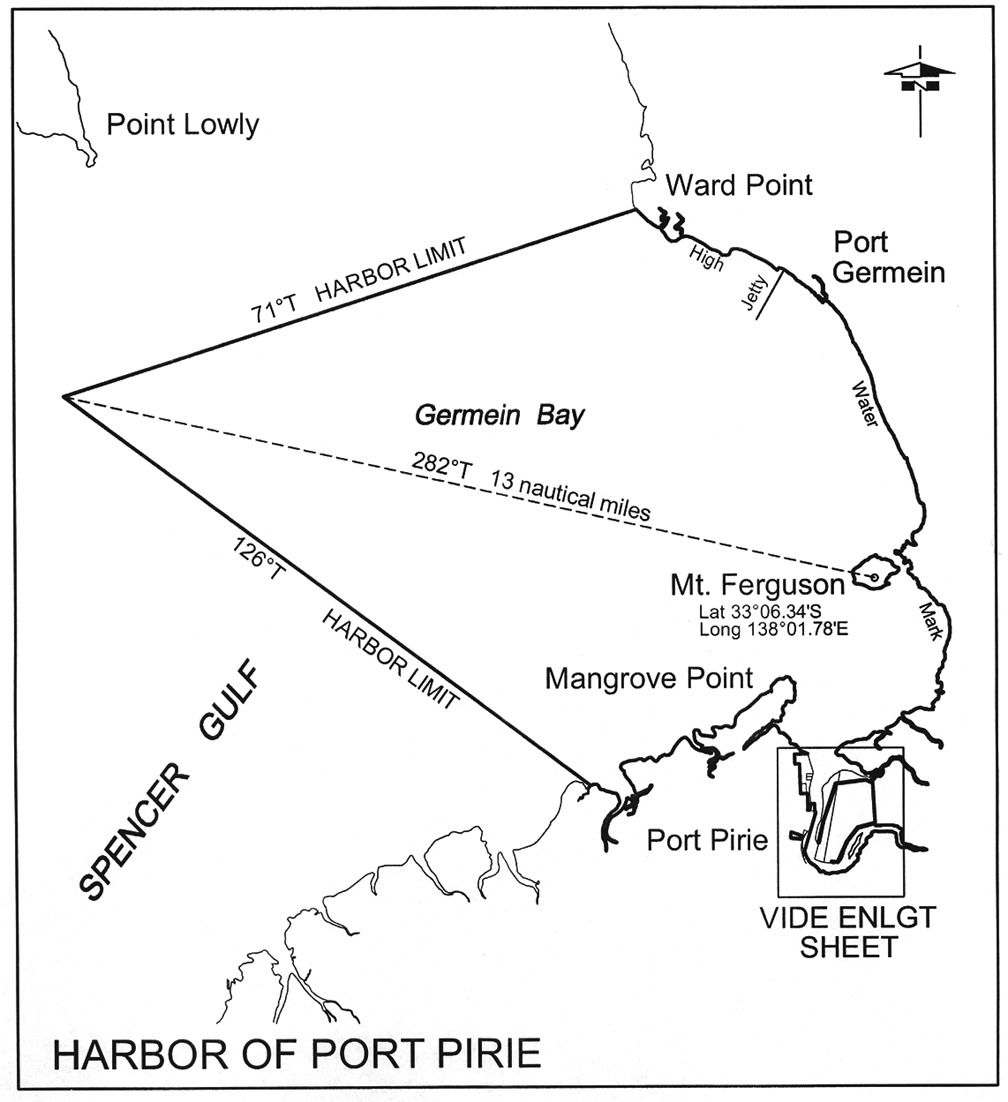
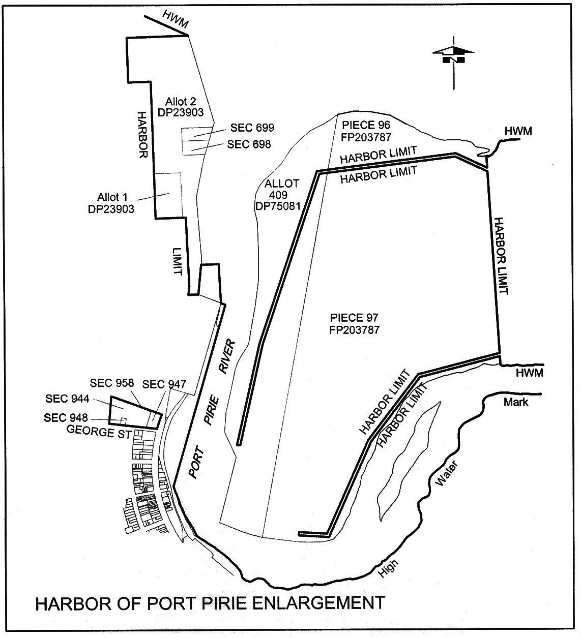
Port Pirie
The following areas:
(a) the
subjacent land underlying, and the adjacent land extending from, the waters,
rivers, creeks and inlets to the High Water Mark in Germein Bay, Spencer Gulf,
commencing at a point on a line bearing 282° True and
distant 13 nautical miles from Mount Ferguson
(latitude 33°06.34′ South,
longitude 138°01.78′ East) situated in Section 1,
Hundreds of Telowie and Pirie, then by a line bearing 126° True
to the High Water Mark on the shore, generally easterly, generally southerly
and generally northerly following that High Water Mark to a point being its
intersection with a line bearing 71° True from the point of
commencement, then west-south-westerly along the latter line to the point of
commencement;
(b) the
following parcels of land:
• Allotments 409
of Deposited Plan No 57081
• Pieces 96 and
97 in Filed Plan 203787
• Sections 698,
699, 944, 947, 948 and 958, Hundred of Pirie.
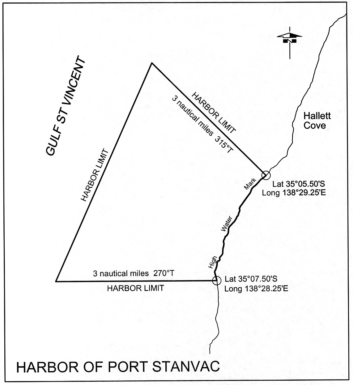
Port Stanvac
The subjacent land underlying, and the adjacent land extending from, the
waters, rivers, creeks and inlets to the High Water Mark on the eastern side
of Gulf St. Vincent bounded as follows:
(a) on
the north-east by a line bearing 315° for 3 nautical miles from
the High Water Mark at approximately
latitude 35°05.50′ South,
longitude 138°29.25′ East;
(b) on
the south by a line bearing 270° True for 3 nautical miles
from the High Water Mark at approximately
latitude 35°07.50′ South,
longitude 138°28.25′ East;
(c) on
the north-west by a straight line connecting the extremities of those
boundaries.
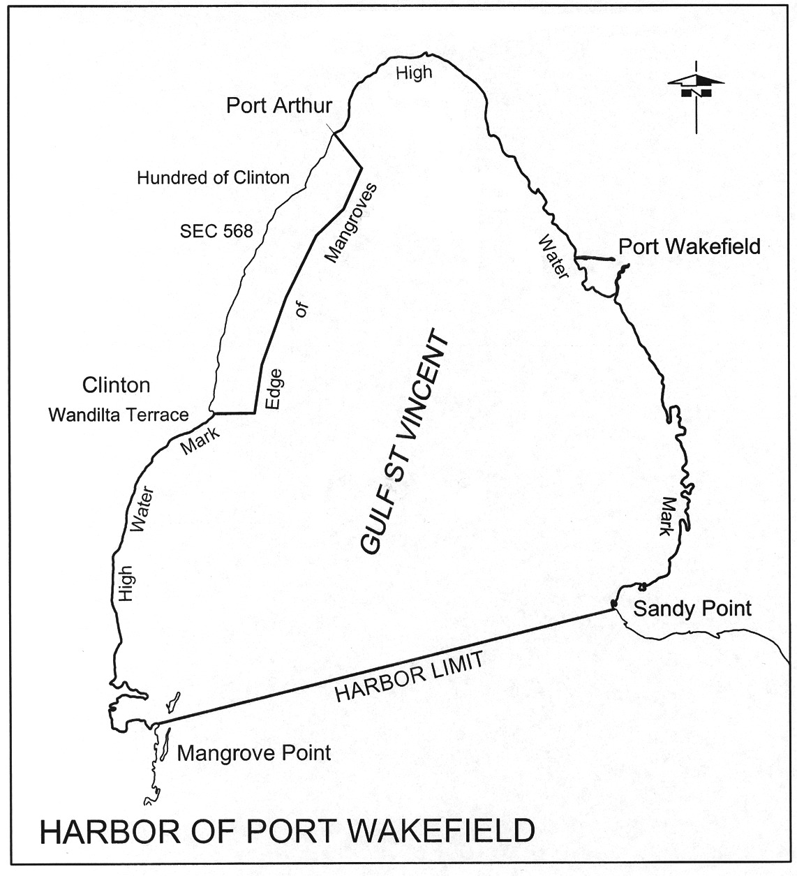
Port Wakefield
The subjacent land underlying, and the adjacent land extending from, the
waters, rivers, creeks and inlets to the High Water Mark of that portion of
Gulf St. Vincent situated to the north of a line drawn from Sandy Point on the
eastern shore to Mangrove Point on the western shore, but excluding an area
commencing at a point being the intersection of the production easterly of the
northern boundary of Wandilta Terrace, Town of Clinton, Hundred of Clinton,
with the eastern edge of the mangroves along the western shore of Gulf St.
Vincent, then westerly along that production and portion of boundary to the
High Water Mark, then generally northerly along the High Water Mark to its
intersection with the production south-easterly of the north-eastern boundary
of Section 568 in the Hundred of Clinton, then generally southerly
following that edge of the mangroves to the point of commencement.
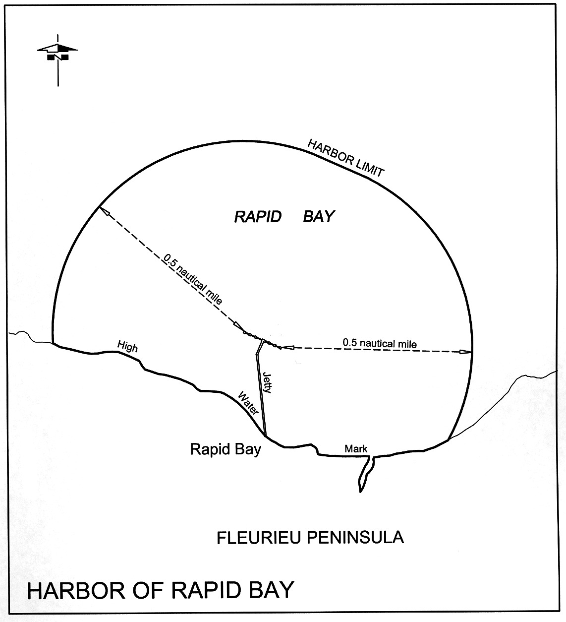
Rapid Bay
The subjacent land underlying, and the adjacent land extending from, the
waters, rivers, creeks and inlets to the High Water Mark within
0.5 nautical miles seaward of any part of the Rapid Bay Jetty.
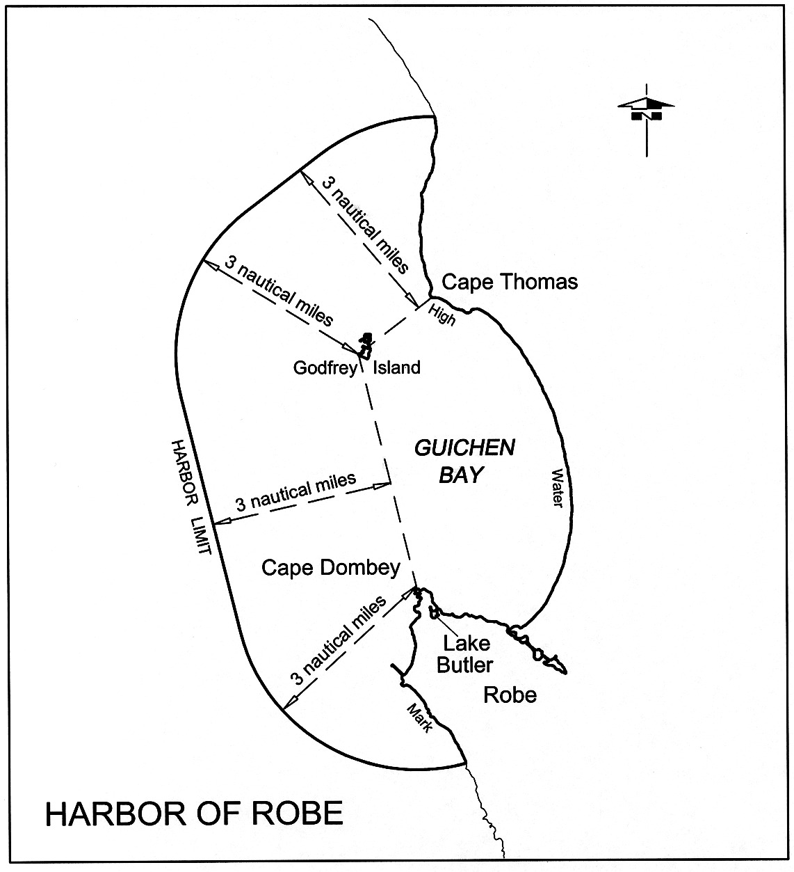
Robe
The subjacent land underlying, and the adjacent land extending from, the
waters, rivers, creeks and inlets to the High Water Mark of Guichen Bay, Lake
Butler, including the entrance channel, as embraced within straight lines
drawn from Cape Dombey to the outward point of Godfrey Island, and from there
to Cape Thomas, and over 3 nautical miles to seaward, measured from any
point on these lines.
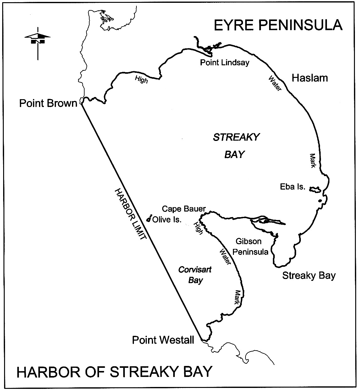
Streaky Bay
The subjacent land underlying, and the adjacent land extending from, the
waters, rivers, creeks and inlets to the High Water Mark to the north and east
of a line joining Point Brown to Point Westall.
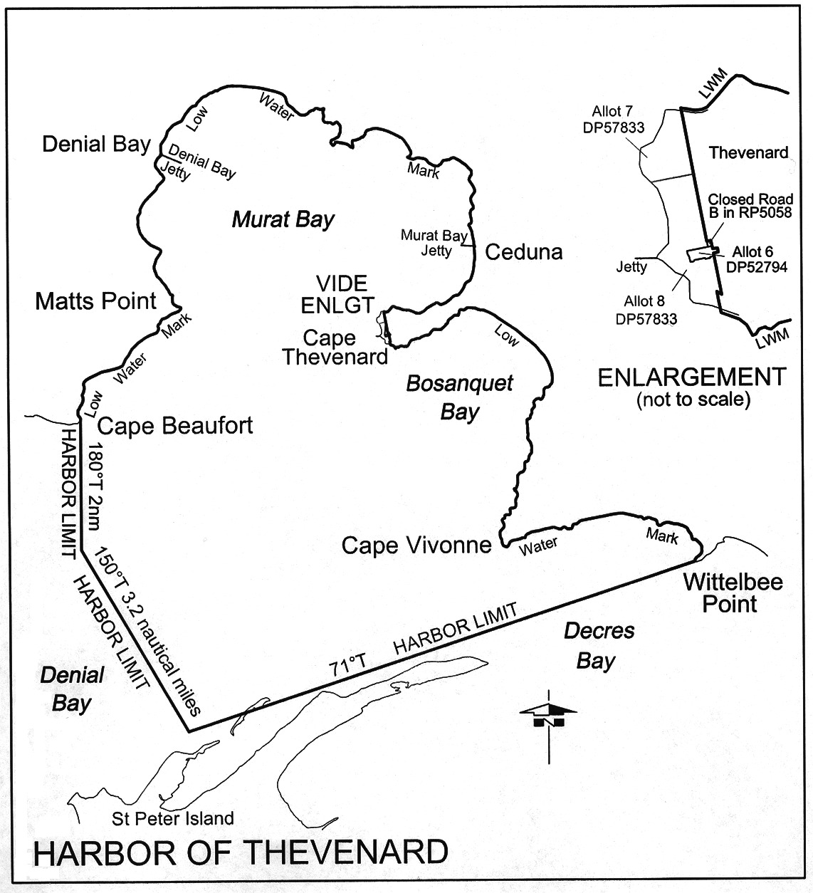
Thevenard
The following areas:
(a) the
subjacent land underlying the waters, rivers, creeks and inlets to the Low
Water Mark of portions of Denial Bay, Murat Bay, Bosanquet Bay, and D'Ecres
Bay bounded as follows:
commencing at the Low Water Mark, Cape Beaufort, Hundred of Moule, then true
south for 2 nautical miles, then 150° True for
3.2 nautical miles, then 71° True on a straight line to the Low
Water Mark at Wittelbee Point, Hundred of Bonython, then along the Low Water
Mark in a westerly, northerly, westerly, and southerly direction to the point
of commencement, and including—
• that portion
of the foreshore 30.48 m wide being 15.24 m on each side of the
centre line of the Denial Bay Jetty, situated opposite Main Street,
Denial Bay, Hundred of Moule, extending from the High Water Mark to the Low
Water Mark; and
• that portion
of the foreshore 30.48 m wide being 15.24 m on each side of the
centre line of the Murat Bay Jetty, situated opposite McKenzie Street, Ceduna,
Hundred of Bonython, extending from the High Water Mark to the Low Water Mark;
(b) the
whole of the land comprised in—
• Allotments 7
and 8 in Deposited Plan No 57833
• Allotment 6 in
Deposited Plan No 52794
• Closed Road B
in Road Plan 5058.
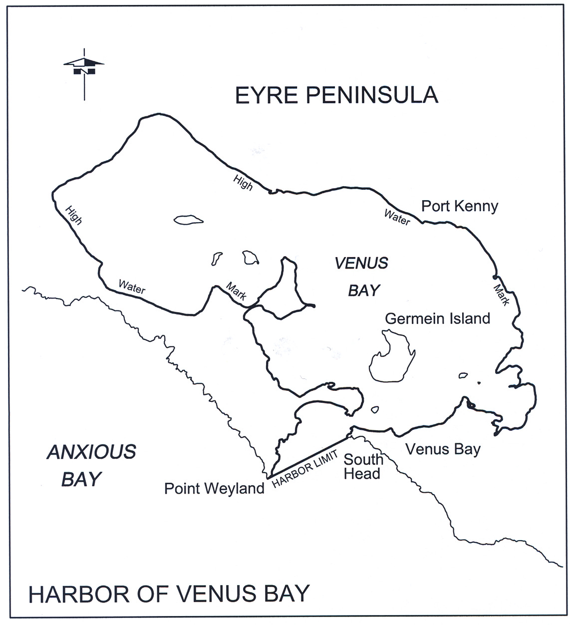
Venus Bay
The subjacent land underlying, and the adjacent land extending from, the
waters, rivers, creeks and inlets to the High Water Mark of Venus Bay,
including the islands of the bay and the subjacent land underlying, and the
adjacent land extending from, waters to the north of a straight line between
Point Weyland and South Head.
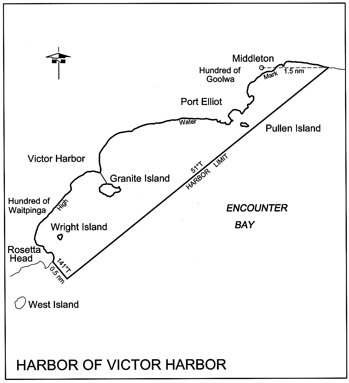
Victor Harbor
The subjacent land underlying, and the adjacent land extending from, the
waters, rivers, creeks and inlets to the High Water Mark bounded as follows:
commencing at the intersection of the High Water Mark and a line
running 141° True from Rosetta Head, Hundred of Waitpinga; then
south-westerly along that line for 0.5 nautical miles; then along a
line 51° True to the High Water Mark about 1.5 nautical miles
eastward from Middleton, Hundred of Goolwa; then westerly and south-westerly
along the High Water Mark to the point of commencement.
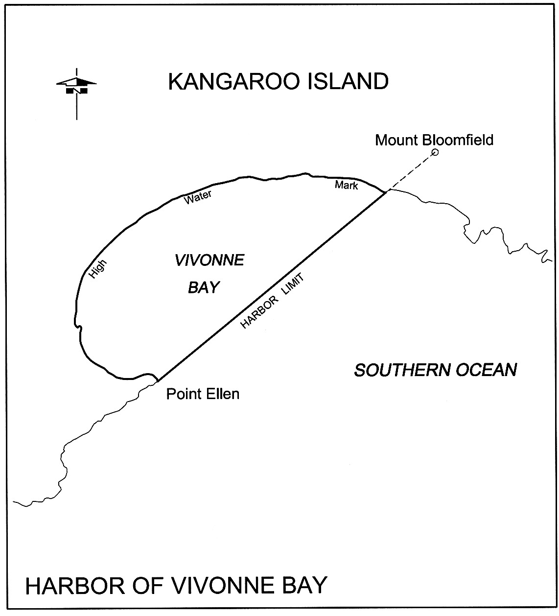
Vivonne Bay
The subjacent land underlying, and the adjacent land extending from, the
waters, rivers creeks and inlets to the High Water Mark to the north of a line
joining Point Ellen to Mount Bloomfield.
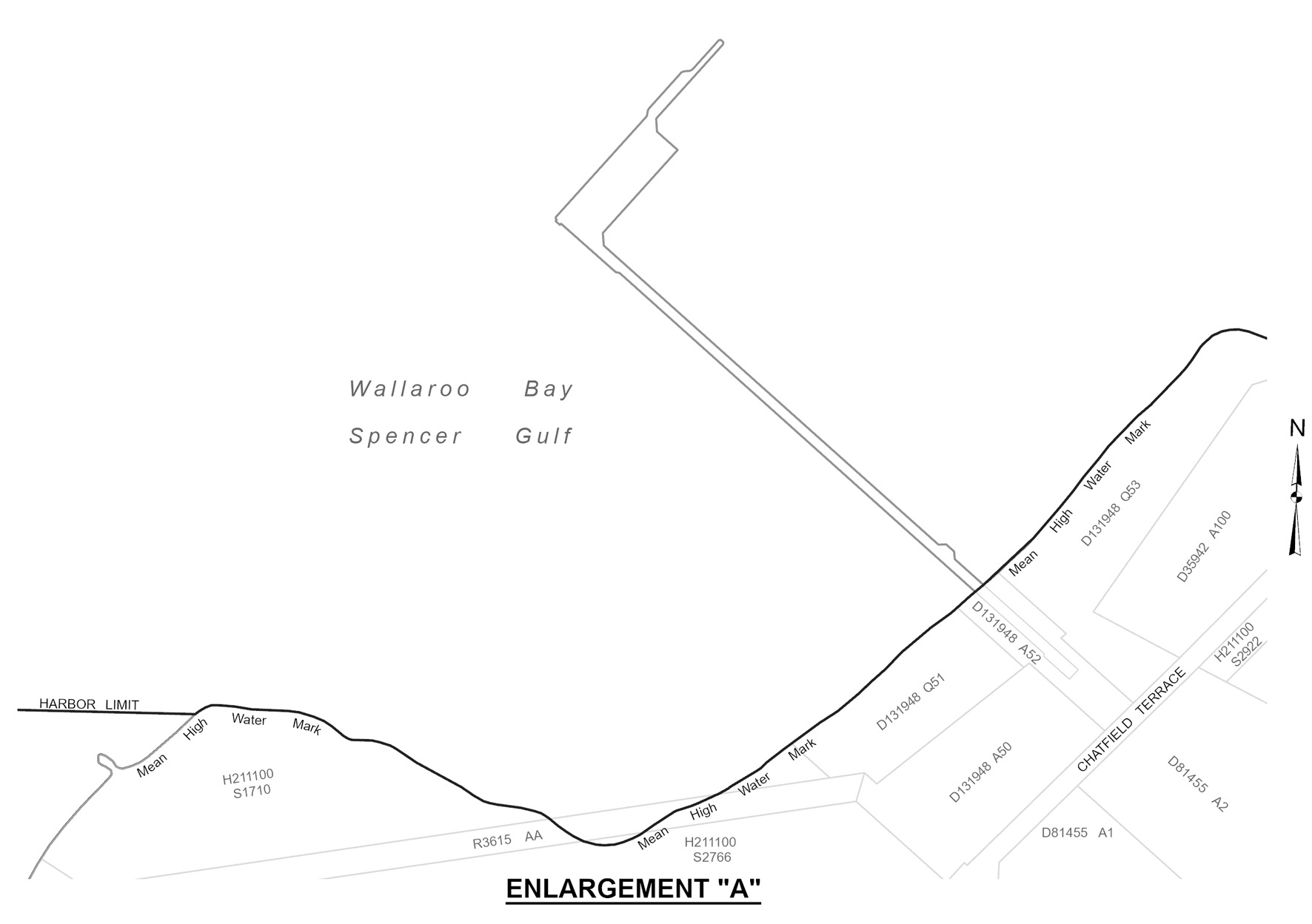
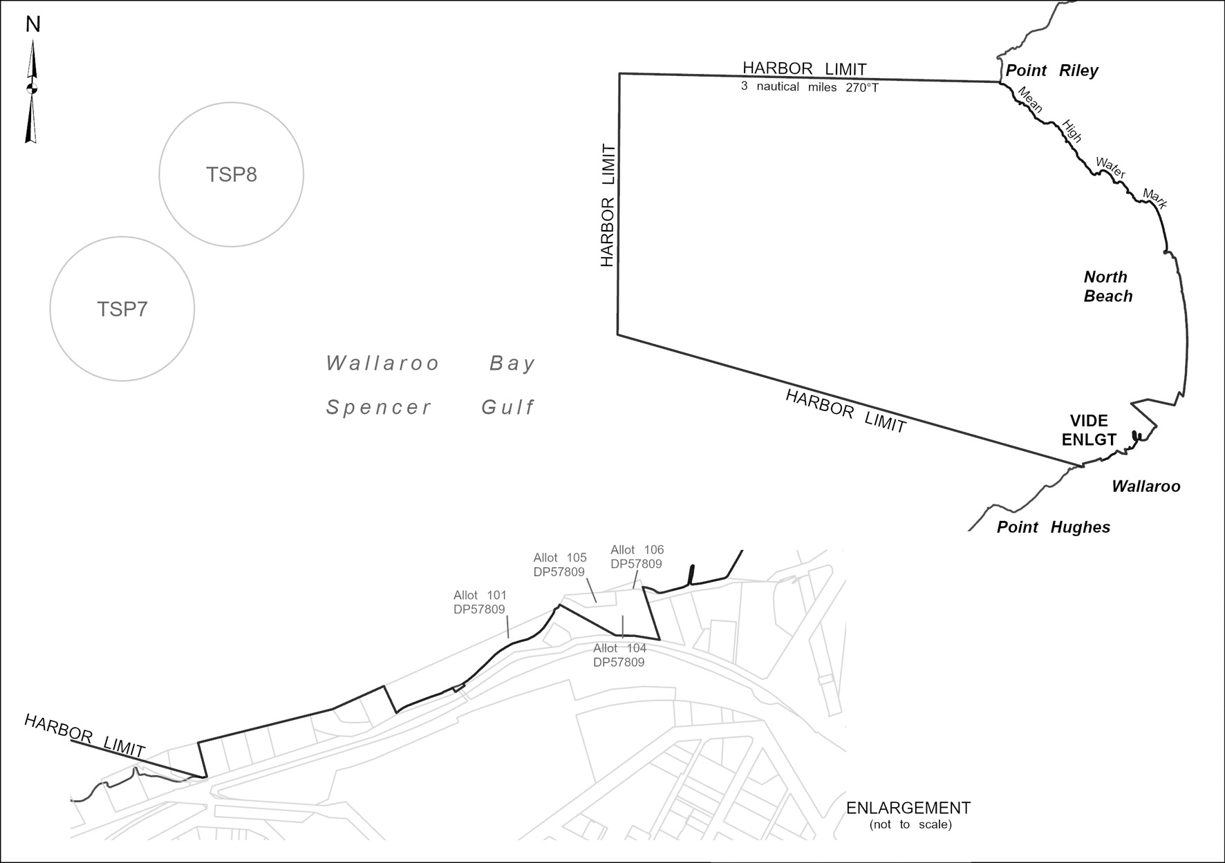
Wallaroo
The following areas:
(a) the
subjacent land underlying, and the adjacent land extending from, the waters,
rivers, creeks and inlets to the High Water Mark of that part of Wallaroo Bay
bounded as follows:
(i)
on the north by a line extending due west for 3 nautical
miles from a point on High Water Mark at the south-west extremity on Point
Riley at longitude 137°36'02.92" East;
(ii)
on the west by a line from the seaward extremity of the
north boundary to latitude 33°54'50.72" South, longitude
137°32'29.20" East;
(iii)
on the south by a line from latitude 33°54'50.72"
South, longitude 137°32'29.20" East to a point on the High Water Mark at
longitude 137°36'55.68" East;
(iv)
on the east commencing at a point on the High Water Mark
at longitude 137°36'55.68" East and continuing in a general north-east
direction along High Water Mark to its intersection with Allotment 1003 in
Deposited Plan No 56470, continuing in a clockwise direction along the
boundary of Allotment 1003 in Deposited Plan No 56470 to its intersection with
Piece 915 in Deposited Plan No 36451, then clockwise along the boundary of
Piece 915 in Deposited Plan No 36451 to the High Water Mark, then generally
northerly along the High Water Mark to the point of commencement,
but excluding—
(v)
Allotment 247 in Filed Plan No 189999
(vi)
Allotment 248 in Filed Plan No 190000
(vii)
Allotment 249 in Filed Plan No 190001
(viii)
Allotment 250 in Filed Plan No 190002
(ix)
Pieces 100 and 101 in Filed Plan No 178342
(x)
Allotments 316 and 251, Town of Wallaroo;
(b) the
whole of the land comprised in Certificate of Title Register Book Allotments
101, 104, 105 and 106 in Deposited Plan No 57809.
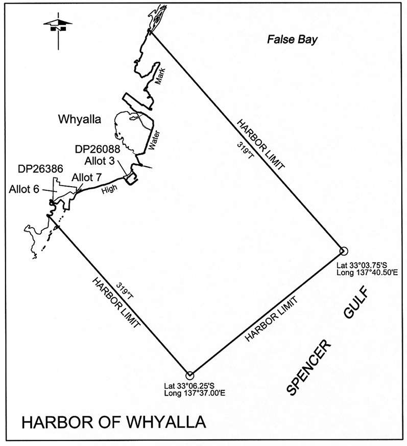
Whyalla
The subjacent land underlying, and the adjacent land extending from, the
waters, rivers, creeks and inlets to the High Water Mark of that portion of
the western coast of Spencer Gulf bounded as follows:
commencing at point latitude 33°03.75′ South,
longitude 137°40.50′ East, then by a straight line to
latitude 33°06.25′ South,
longitude 137°37.00′ East, then on a line
bearing 319° True to the High Water Mark, then generally
north-easterly following the High Water Mark to its intersection with a line
bearing 319° True from the point of commencement, then from the
latter line to the point of commencement but excluding that portion comprising
land reclaimed as follows:
• that portion
of Allotment 6 in Deposited Plan No 26386, Hundred of Randell,
situated between the Old Medium High Water Mark and the Toe of Bank of
Reclaimed Area delineated on that Plan;
• that portion
shown on Deposited Plan No 26386 as situated between the southern
boundary of Allotment 7 and the Medium High Water Mark;
• Allotment 3 in
Deposited Plan No 26088, Hundred of Randell and Out of Hundreds
(Whyalla).