South Australian Current Regulations South Australian Current Regulations
Editorial note—
Unless the contrary intention appears, the maps in this Schedule are provided
for convenience of reference only.
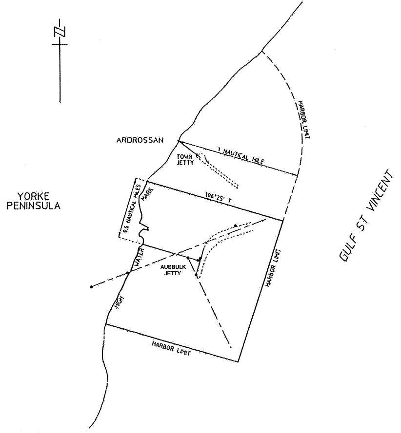
Ardrossan
The subjacent land underlying, and adjacent land extending from, the waters,
rivers, creeks and inlets to the High Water Mark of that portion of the
western coast of Gulf St. Vincent bounded as follows:
commencing at a point on the High Water Mark distant 0.5 nautical miles
north-north-easterly of the centre line of the Ausbulk Jetty; then by a line
bearing 106°25′ True to its intersection with eastern
boundary of the harbor of Ardrossan; then by the boundary of the harbor of
Ardrossan generally south-south-westerly, west-north-westerly,
north-north-easterly (along the High Water Mark) to the point of commencement.
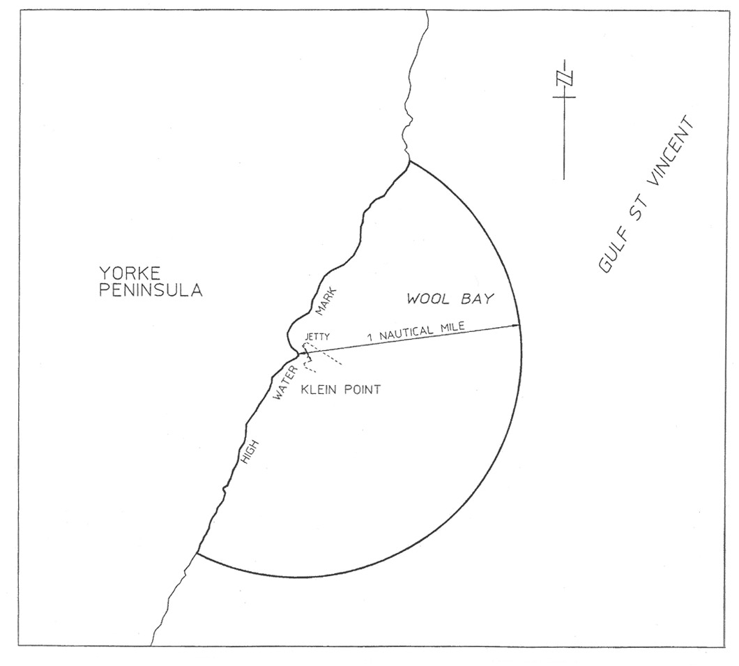
Klein Point
The subjacent land underlying, and adjacent land extending from, the waters,
rivers, creeks and inlets to the High Water Mark of that portion of the
western coast of Gulf St. Vincent within 1 nautical mile seaward of the
intersection of the High Water Mark and the Klein Point Jetty.
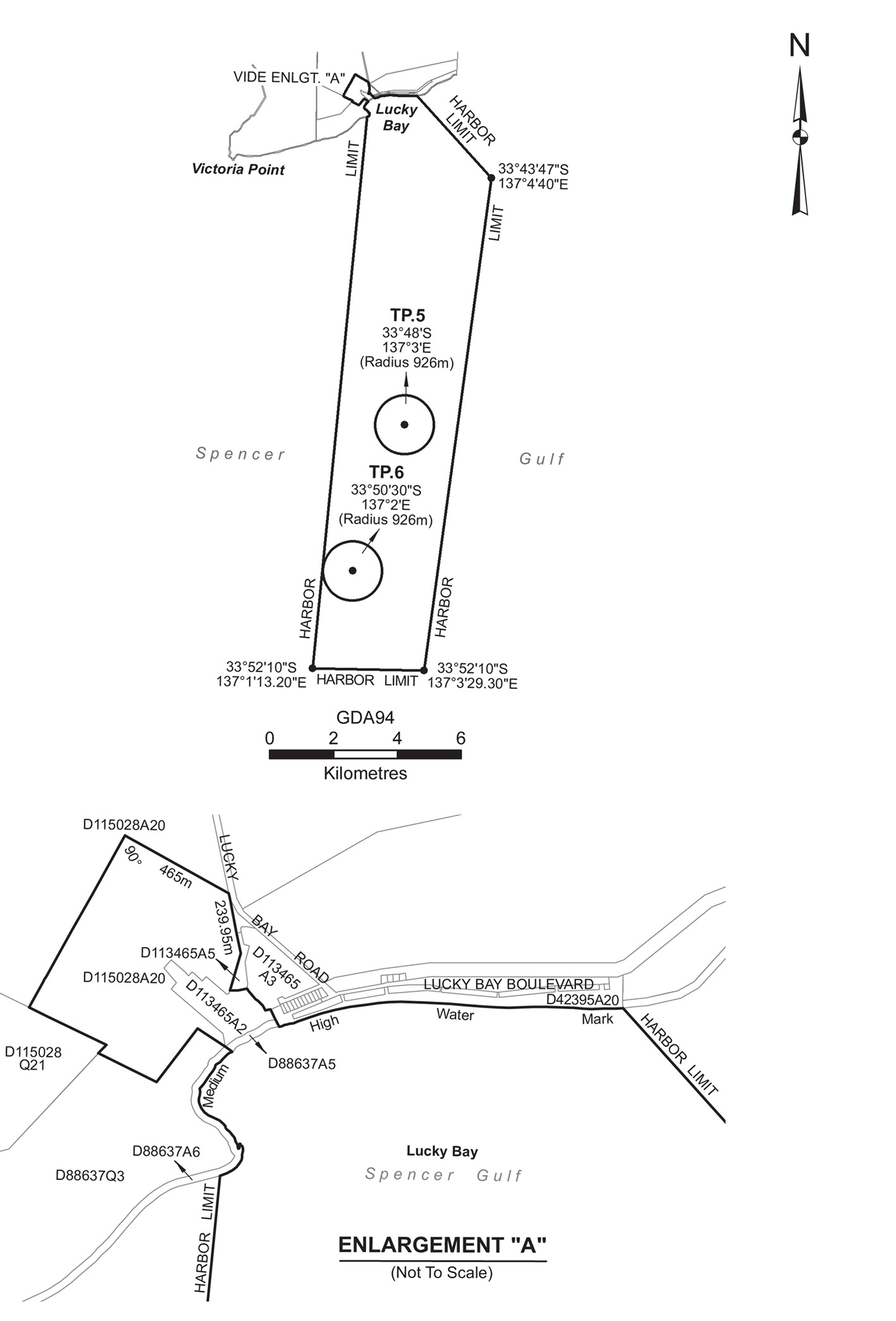
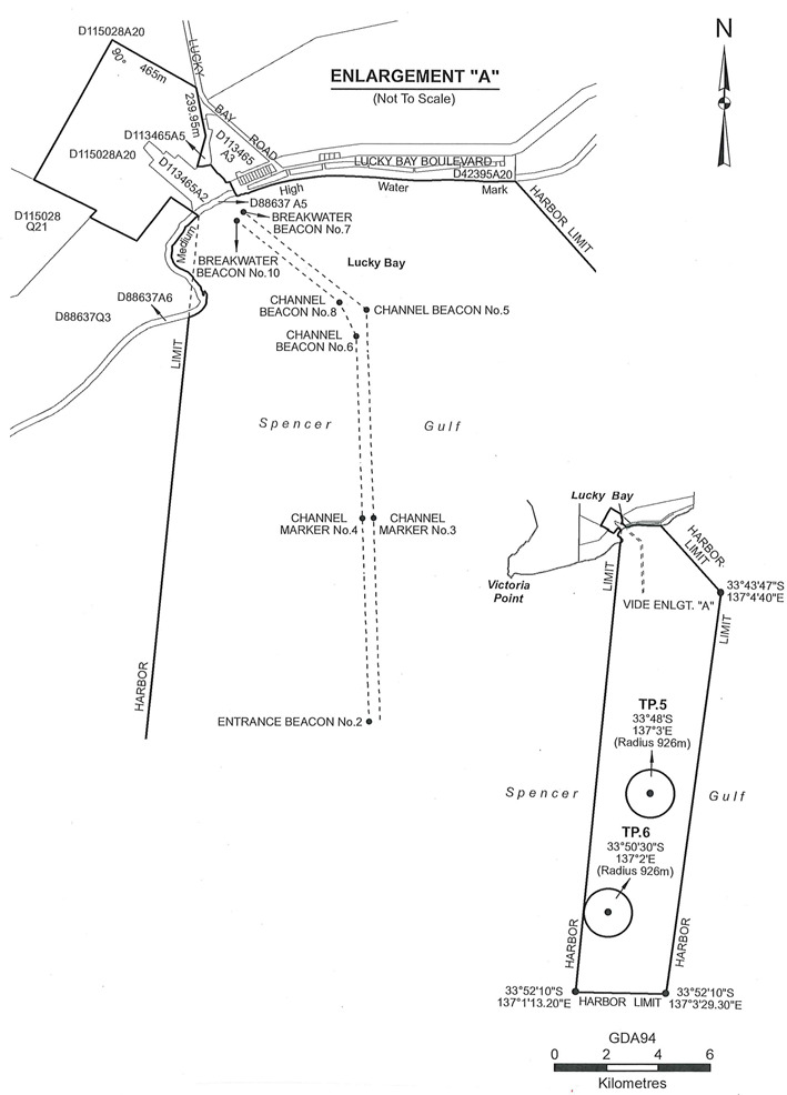
Lucky Bay
The area bounded as follows:
commencing at a point (being the northernmost
corner of the Lucky Bay Harbor) situated on the north-eastern boundary of
Allotment 1 in Deposited Plan 113465 being the back bearing of
299°14′40″ from the intersection of the western boundary of
Lucky Bay Road and the southernmost corner of Piece 13 in Deposited
Plan 94729 for a distance of 465 m, then south-easterly on a bearing
of 119°14′40″ for a distance of 465 m to the western
boundary of Lucky Bay Road, then southerly on a bearing of
168°27′20″ along the western boundary of Lucky Bay Road and
its production along an eastern boundary of Allotment 20 in Deposited
Plan 115028 for a distance of 239.95 m, then southerly on a bearing
of 195°57′50″ for a distance of 153.18 m, then easterly
on a bearing of 88°06′00" for a distance of 30.66 m, then
easterly on a bearing of 78°50′00" for a distance of 35 m,
then easterly on a bearing of 100°46′00" for a distance of
3.25 m, then south-easterly on a bearing of 150°10′30″
for a distance of 7.5 m, then south-easterly on a bearing of
140°07′30″ for a distance of 44 m, then south-easterly
on a bearing of 120°29′30″ for a distance of 13 m, then
south-easterly on a bearing of 136°20′30″ for a distance of
27 m, then south-easterly on a bearing of 150°45′30″ for
a distance of 21 m, then north-easterly on a bearing of
65°03′30″ for a distance of 15.02 m, then south-easterly on a
bearing of 152°42′10″ for a distance of approximately
86 m to the Medium High Water Mark, then easterly along the Medium High
Water Mark to a point being the production southerly of the eastern boundary
of Allotment 20 in Deposited Plan 42395 to the intersection of the
said Medium High Water Mark, then south-easterly along the Harbor Limit
boundary to a point being at Longitude 137°4′40″ East and
Latitude 33°43′47″ South, then southerly along the eastern
Harbor Limit boundary to a point being at Longitude
137°3′29.30″ East and Latitude 33°52′10″
South, then westerly along the southern Harbor Limit boundary to a point being
at Longitude 137°1′13.20″ East and Latitude
33°52′10″ South, then northerly along the western Harbor
Limit boundary to a point on the Medium High Water Mark being the intersection
of an arbitrary straight line from Longitude 137°1′13.20″
East and Latitude 33°52′10″ South to the southernmost corner
of Allotment 5 in Deposited Plan 88637, then generally northerly
along the Medium High Water Mark to the southernmost corner of
Allotment 5 in Deposited Plan 88637, then north-westerly on a
bearing of 307°41′30″ for a distance of approximately
157.6 m, then south-westerly on a bearing of 217°41′30″
for a distance of 265 m, then north-westerly on a bearing of
296°20′00" for a distance of 254.08 m to the eastern boundary
of Piece 21 in Deposited Plan 115028, then north-easterly on a
bearing of 43°01′40″ for a distance of 57.54 m, then
north-westerly on a bearing of 296°14′20″ to a point on a
southern boundary of Allotment 20 in Deposited Plan 115028 being the
intersection of an arbitrary straight line heading in a south-westerly
direction with an internal angle of 90° from the point of commencement to
the said intersection, then north-easterly from the said intersection back to
the point of commencement.
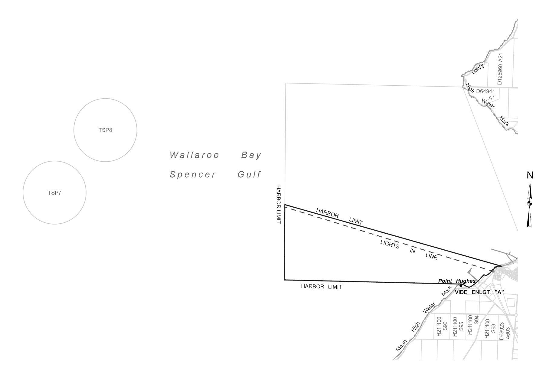
Narungga
The subjacent land underlying, and the adjacent land extending from, the
waters, rivers, creeks and inlets to the High Water Mark of that part of
Wallaroo Bay bounded as follows:
commencing at a point on the High Water Mark at longitude 137°36'04.71"
East and the northern extremity of Point Hughes, then westerly for 3 nautical
miles to latitude 33°56'07.41" South, longitude 137°32'30.69" East,
then northerly to latitude 33°54'50.72" South, longitude
137°32'29.20" East, then generally south easterly for 3.8 nautical miles
to a point on the High Water Mark at longitude 137°36'55.68" East, then
generally south westerly along the High Water Mark back to the point of
commencement.
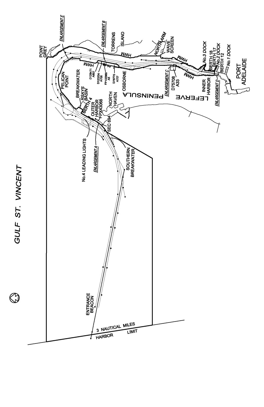
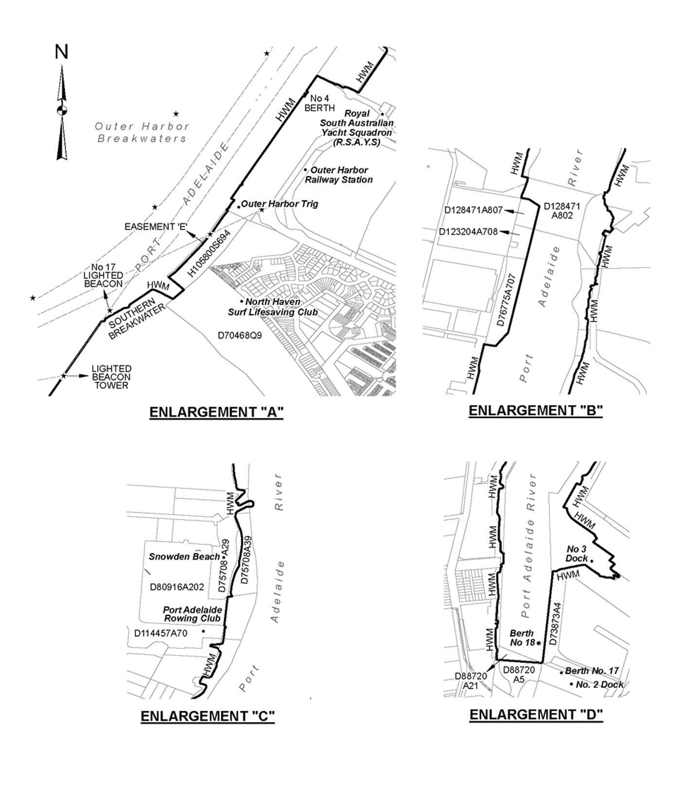
Port Adelaide
(3) The subjacent land
underlying, and adjacent land extending from, the waters, rivers, creeks and
inlets to the High Water Mark bounded as follows:
• commencing at
Point Grey then due west along a line to its intersection with the western
boundary of the harbor of Port Adelaide;
• then generally
south-south-easterly along the harbor boundary for 3 nautical miles;
• then along a
line due east to its intersection with the south-westerly production of the
Number 4 Leading Lights;
• then generally
north-easterly along the production to its intersection with the High Water
Mark on the southern face of the southern breakwater;
• then generally
north-easterly along the High Water Mark to its intersection with the
south-western boundary of Section 694 Hundred of Port Adelaide;
• then generally
north-westerly along that boundary of Section 694 Hundred of Port
Adelaide to its intersection with the south-eastern boundary of
easement E on FPX 43068;
• then generally
north-easterly along that boundary of easement E on FPX 43068 to its
intersection with the north-western boundary of Section 694 Hundred of Port
Adelaide;
• then generally
north-westerly along that boundary of Section 694 Hundred of Port
Adelaide across the southern breakwater to its intersection with the High
Water Mark on the northern face of the southern breakwater;
• then generally
north-easterly along the High Water Mark to the northern extremity of
Number 4 berth;
• then generally
south-easterly along the High Water Mark to its intersection with the
production southerly of the High Water Mark on the western face of the
breakwater at the Royal South Australian Yacht Squadron (RSAYS);
• then generally
north-easterly along the production across the RSAYS basin;
• then generally
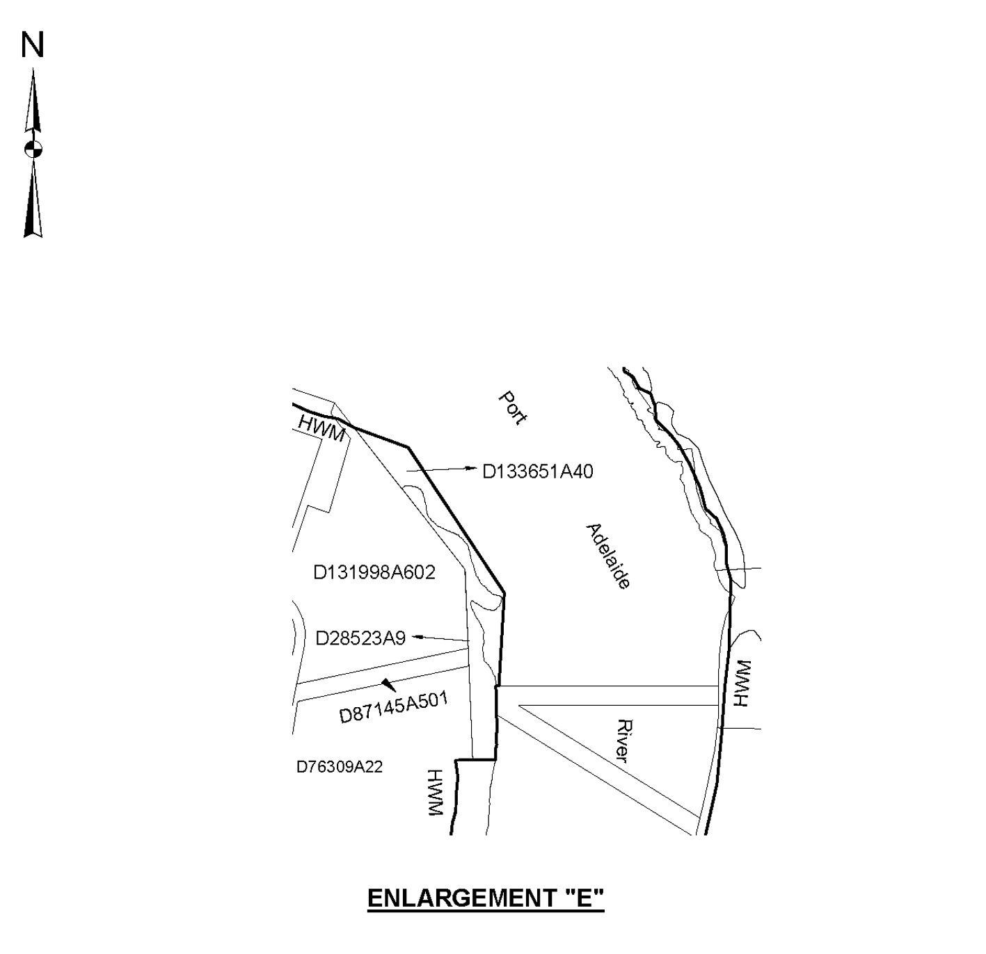
north-westerly and north-easterly along the High Water Mark to Pelican Point;
• then generally
south-easterly along the High Water Mark to its intersection with the northern
boundary of Allotment 40 in DP 133651;
• then generally
south-easterly and southerly along the northern and eastern boundaries of
Allotment 40 in DP 133651 and westerly along the southern boundary
of Allotment 40 in DP 133651 to its intersection with the eastern boundary of
Allotment 9 in DP 28523;
• then generally
southerly along the eastern boundary of Allotment 9 in DP 28523 and
westerly along the southern boundary of Allotment 9 in DP 28523 and
its production to its intersection with the High Water Mark;
• then generally
southerly along the High Water Mark to its intersection with the northern
boundary of Allotment 807 in DP 128471;
• then generally
easterly and southerly along the northern and eastern boundaries of
Allotment 807 in DP 128471;
• then generally
southerly along the eastern boundaries of Allotment 708 in DP 123204
and Allotment 707 in DP 76775 and westerly along the southern
boundary of Allotment 707 in DP 76775 to its intersection with the
High Water Mark;
• then generally
southerly along the High Water Mark to the south-eastern corner of
Allotment 29 in DP 75708;
• then generally
southerly along a straight line connecting that corner of Allotment 29 in
DP 75708 to the north-eastern corner of Allotment 70 in
DP 114457;
• then generally
south-westerly and southerly along the High Water Mark to its intersection
with a line across the Port Adelaide River perpendicular to the western
boundary of Allotment 4 in DP 73873 (face of Number 18 berth)
and connecting the western side of the Port Adelaide River with the
south-western corner of Allotment 4 in DP 73873;
• then generally
easterly along that perpendicular line across the Port Adelaide River to its
intersection with the High Water Mark;
• then generally
northerly and north-easterly along the High Water Mark, including
Number 3 dock, to its intersection with the Wave Screen in North Arm;
• then generally
northerly along the western face of the Wave Screen and its northerly
production to intersect with the High Water Mark on Torrens Island;
• then generally
northerly along the High Water Mark to the point of commencement at Point
Grey.
Port Giles
The subjacent land underlying, and adjacent land extending from, the waters,
rivers, creeks and inlets to the High Water Mark of that portion of the
western coast of Gulf St. Vincent bounded as follows:
commencing at a point on the High Water Mark 1 nautical mile due south of
the intersection of the centre line of the Port Giles Jetty with the High
Water Mark; then by a line bearing due east from the High Water Mark for
3 nautical miles; then by a line bearing due north for 2 nautical
miles; then by a line bearing due west to the High Water Mark; then generally
southerly along the High Water Mark to the point of commencement.
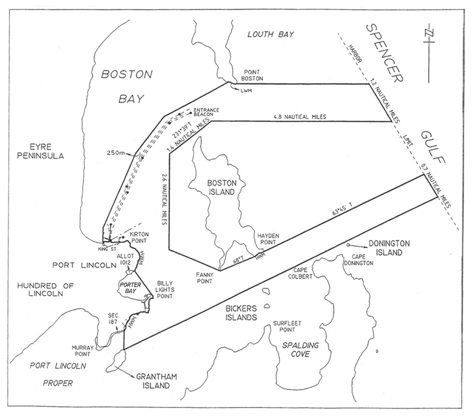
Port Lincoln
The subjacent land underlying, and adjacent land extending from, the waters,
rivers, creeks and inlets to the High Water Mark of Port Lincoln bounded as
follows:
commencing at the intersection with the High Water Mark of a line running due
north from the north-east corner of King and Porter Streets; then due north
along that line to its intersection with a line 250 m from and parallel
to the port side of the maintained channel; then generally north-easterly by a
line 250 m from and parallel to the port side of the maintained channel
to a point adjacent the entrance beacon; then continuing generally
north-easterly along the production of that line to its intersection with the
Low Water Mark; then along the Low Water Mark to Point Boston; then due east
along a line to its intersection with the eastern boundary of the harbor of
Port Lincoln; then generally south-easterly along the harbor boundary for
1.2 nautical miles; then due west along a line for 4.8 nautical
miles; then along a line bearing 231°39′ True for
1.4 nautical miles; then due south along a line for 2.6 nautical
miles; then generally south-easterly along a line to the High Water Mark at
Fanny Point; then along a line bearing 68° True or thereabouts to
its intersection with the High Water Mark on Boston Island; then along the
High Water Mark on Boston Island to Hayden Point; then by a line
bearing 63°45′ True to its intersection with the eastern
boundary of the harbor of Port Lincoln; then generally south-easterly along
the harbor boundary for 0.7 nautical miles; then generally south-westerly
by a line to the High Water Mark on the northern tip of Grantham Island; then
due north along a line to its intersection with the High Water Mark adjacent
Section 187 Hundred of Lincoln; then generally north-easterly and
northerly along the High Water Mark to Billy Lights Point; then by a line
generally north-westerly to its intersection with the High Water Mark and the
western corner of Allotment 1012, Town of Port Lincoln; then generally
northerly and westerly along the High Water Mark to the point of commencement.
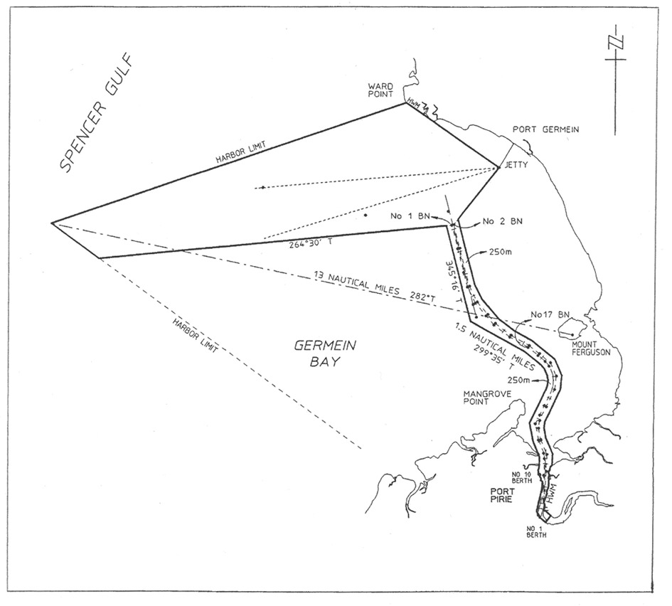
Port Pirie
The subjacent land underlying, and adjacent land extending from, the waters,
rivers, creeks and inlets to the High Water Mark in Germein Bay, Spencer Gulf,
bounded as follows:
commencing at a point on a line bearing 282° True and distance
13 nautical miles from Mount Ferguson
(latitude 33°06.34′ South,
longitude 138°01.78′ East); then generally north-easterly
along the north-western harbor boundary to the High Water Mark; then generally
south-easterly along a line to the Port Germein jetty light; then generally
south-westerly along a line joining No 2 port beacon to the intersection
point of a line 250 m from and parallel to the port side of the
maintained channel; then generally southerly and south-easterly by a line
250 m from and parallel to the port side of the maintained channel to its
intersection with the High Water Mark; then generally southerly along the High
Water Mark to a point being the prolongation of the southern extremity of
No 1 berth Port Pirie across the Port Pirie River; then generally
south-westerly across the Port Pirie River along that prolongation to the
southern extremity of No 1 berth Port Pirie; then generally
north-westerly and northerly along the High Water Mark to the northern
extremity of No 10 berth; then generally westerly along the No 10
berth to its intersection with the High Water Mark; then generally northerly
along the High Water Mark to the intersection of a line 250 m from and
parallel to the starboard side of the maintained channel; then generally north
and north-westerly by a line 250 m from and parallel to the starboard
side of the maintained channel to a point south-west of the No 17
starboard beacon; then by a line bearing 299°35′ True for
1.5 nautical miles; then by a line bearing 345°16′ True
to the intersection point of a line bearing 264°30′ True from
No 1 starboard beacon; then by a line bearing 264°30′
True to the intersection with the south-western limit of the harbor of Port
Pirie; then generally north-westerly along the south-western limit of the
harbor of Port Pirie to the point of commencement.
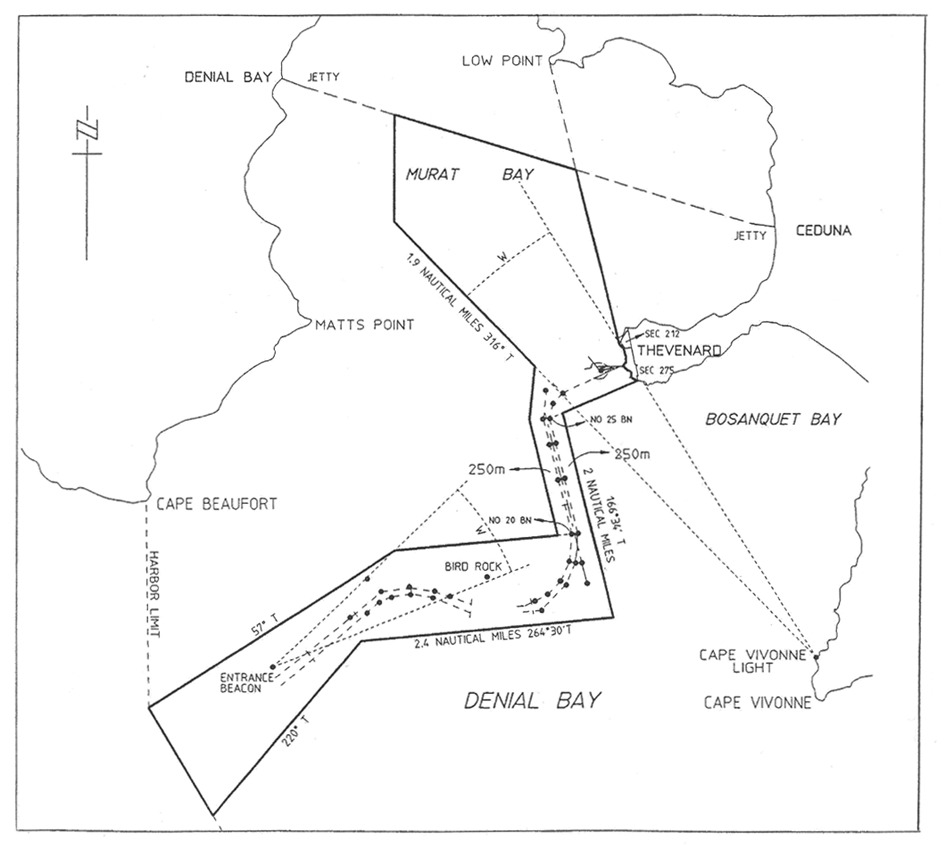
Thevenard
The subjacent land underlying, and adjacent land extending from, the waters,
rivers, creeks and inlets to the High Water Mark of Denial Bay, Murat Bay and
Bosanquet Bay bounded as follows:
commencing at a point at the intersection of the High Water Mark and the
production south-westerly of the north-western boundary of Section 212
Hundred of Bonython; then generally southerly along the High Water Mark to the
south-western corner of Section 275 Hundred of Bonython; then generally
west-south-westerly along a line joining No 25 starboard beacon to the
intersection point of a line 250 m from and parallel to the starboard
side of the maintained channel; then by that line
bearing 166°34′ True for 2 nautical miles; then by a
line bearing 264°30′ True for 2.4 nautical miles;
then by a line bearing 220° True to its intersection with the
south-western boundary of the harbor of Thevenard; then generally
north-westerly along the harbor boundary to a point 2 nautical miles due
south of Cape Beaufort; then by a line bearing 57° True to the
intersection with a line bearing 46° True from the Entrance
beacon (white sector light); then generally easterly by a line joining
No 20 port beacon to the intersection point of a line 250 m from and
parallel to the port side of the maintained channel; then by a series of lines
250 m from and parallel to the port side of the maintained channel to the
intersection point with a line bearing 316° True from Cape
Vivonne (white sector light); then by that line
bearing 316° True for 1.9 nautical miles; then by a line
bearing true north to the intersection point on a line joining Denial Bay
Jetty and Ceduna Jetty; then along that line generally east-south-easterly to
the intersection point of a line joining Low Point and the point of
commencement; then generally southerly along that line to the point of
commencement.
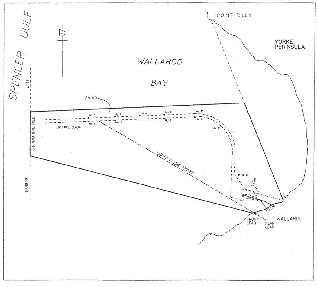
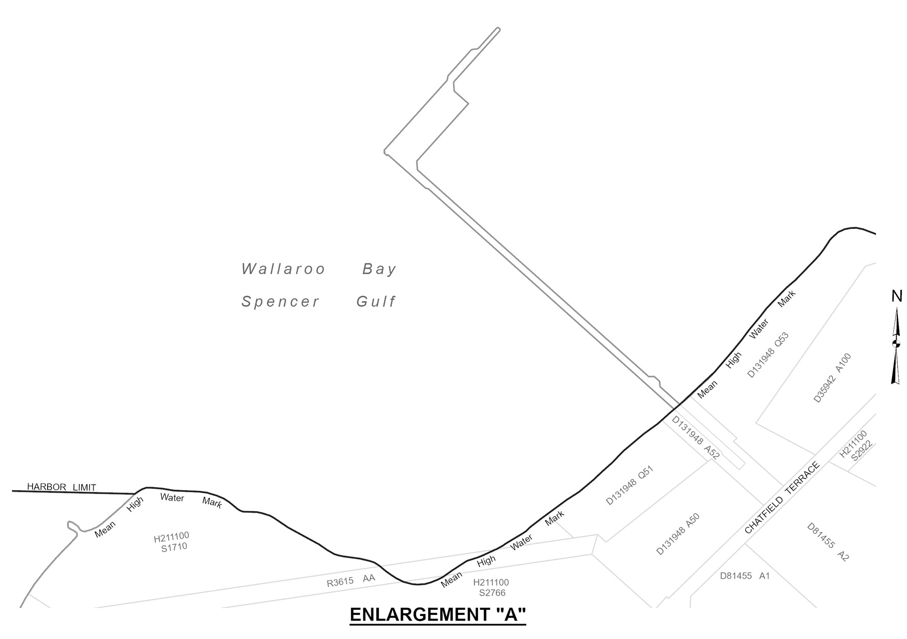
Wallaroo
The subjacent land underlying, and adjacent land extending from, the waters,
rivers, creeks and inlets to the High Water Mark of that part of Wallaroo Bay
bounded as follows:
commencing at a point on the High Water Mark intersected by a line 150 m
north-east and parallel to the northern face of the shipping pier; then
generally north-westerly along a line joining the High Water Mark at the
south-west extremity of Point Riley to the intersection with a line being the
production generally easterly of a line 250 m from and parallel to the
port side of the maintained channel; then generally westerly along that line
to its intersection with western boundary of the harbor of Wallaroo; then
generally southerly along the harbor boundary for 0.6 nautical miles;
then generally east-south-easterly along a line joining the front lead to the
intersection with the High Water Mark; then generally north-easterly along the
High Water Mark to the point of commencement.