 South Australian Current Regulations South Australian Current Regulations
Schedule 7—Speed restrictions in certain waters
Editorial note—
Unless the contrary intention appears, the maps in this Schedule are provided
for convenience of reference only.
The speed limit in the following waters is 7 knots:
(a)
Kangaroo Island
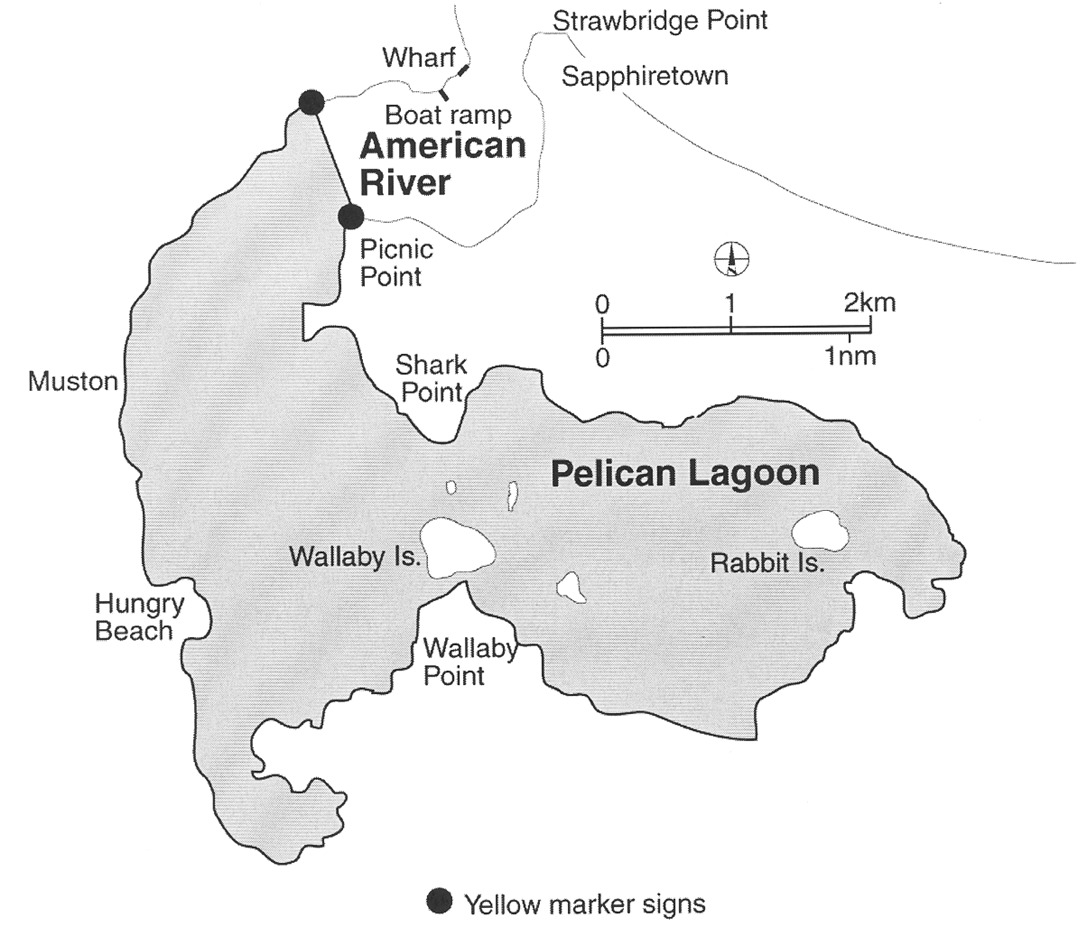
The area, known as the American River Aquatic Reserve, comprising all the
waters of American River upstream of the geodesic commencing at the High Water
Mark on the western shore of American River at position latitude
35°47.5′ South, longitude 137°45.5′ East, then in a
south-easterly direction to the High Water Mark on the eastern shore of
American River, position latitude 35°48′ South, longitude
137°45.8′ East, together with the waters of Pelican Lagoon and all
adjoining creeks and inlets of Pelican Lagoon;
(b) Port
Adelaide
The following areas:
(i)
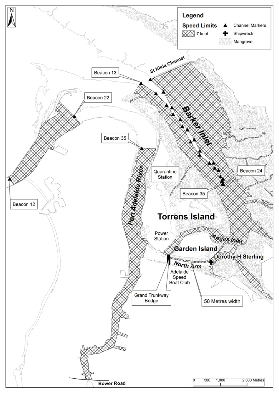
the portion of Barker Inlet, Port Adelaide, south-east of
a line commencing at the south-eastern end of the southern St. Kilda Channel
breakwater, through No 13 Channel Beacon, then south-westerly along a
line bearing 225° to its intersection with the High Water Mark on the
eastern side of Torrens Island, including all inlets and creeks, but not
including the area bounded as follows:
• on the west by
a line commencing at No 13 Channel Beacon and ending at No 35
Channel Beacon, through the following points in GDA94 coordinates:
|
Latitude |
Longitude |
|
34° 45′ 5.72″ South |
138° 30′ 58.17″ East |
|
34° 45′ 18.44″ South |
138° 31′ 16.64″ East |
|
34° 45′ 32.62″ South |
138° 31′ 29.30″ East |
|
34° 45′ 43.63″ South |
138° 31′ 37.25″ East |
|
34° 45′ 58.53″ South |
138° 31′ 48.49″ East |
|
34° 46′ 17.27″ South |
138° 31′ 58.49″ East |
|
34° 46′ 32.24″ South |
138° 32′ 10.58″ East |
|
34° 46′ 42.08″ South |
138° 32′ 22.75″ East |
|
34° 46′ 48.85″ South |
138° 32′ 28.46″ East |
|
34° 46′ 59.44″ South |
138° 32′ 36.19″ East |
|
34° 47′ 4.88″ South |
138° 32′ 37.54″ East |
|
34° 47′ 8.71″ South |
138° 32′ 38.17″ East |
• on the east by
a line commencing at the St. Kilda Starboard Channel marker and ending at
No 24 Channel Beacon through the following points in
GDA94 coordinates:
|
Latitude |
Longitude |
|
34° 45′ 1.17″ South |
138° 31′ 9.41″ East |
|
34° 45′ 16.16″ South |
138° 31′ 25.47″ East |
|
34° 45′ 35.61″ South |
138° 31′ 36.00″ East |
|
34° 45′ 50.23″ South |
138° 31′ 45.92″ East |
|
34° 46′ 2.50″ South |
138° 31′ 54.50″ East |
|
34° 46′ 14.79″ South |
138° 32′ 3.14″ East |
|
34° 46′ 28.42″ South |
138° 32′ 9.94″ East |
|
34° 46′ 43.1″ South |
138° 32′ 26.44″ East |
|
34° 46′ 51.79″ South |
138° 32′ 32.67″ East |
|
34° 47′ 2.68″ South |
138° 32′ 37.67″ East |
|
34° 47′ 9.44″ South |
138° 32′ 38.76″ East |
• on the north
by a straight line commencing at No 13 Channel Beacon and ending at the
St. Kilda Starboard Channel marker;
• on the south
by a straight line commencing at No 35 Channel Beacon and ending at
No 24 Channel Beacon; and
(ii)
the portion of the North Arm of the Port Adelaide River
east of a line bearing 13° from a point at latitude
34°48′44.6″ South, longitude 138°32′23.7″
East in GDA94 coordinates, to the edge of mangroves, including all inlets and
creeks; and
(iii)
the portion of the North Arm of the Port Adelaide River
extending 50 m from the southern edge of mangroves on the southern bank
of Garden Island bounded at one end by the eastern end of the Grand Trunkway
Bridge and at the other by a line bearing 13° from a point at
34°48′44.6″ South, 138°32′23.7″ East in
GDA94 coordinates to the northern edge of mangroves; and
(iv)
Angas Inlet, Port Adelaide; and
(v)
the portion of the Port Adelaide River which lies between
No 12 Channel Beacon and No 22 Channel Beacon; and
(vi)
the portion of the Port Adelaide River which lies south
of No 35 Channel Beacon;
(c) Port
Augusta
The area bounded as follows:
commencing at the intersection of the south-eastern end of Great Western
Bridge and approaches with the High Water Mark, then south-westerly along the
High Water Mark to its intersection with the production shorewards of the
north-eastern end of Port Augusta wharf, then seawards along that production
and the northern end of Port Augusta wharf to the north-eastern corner of the
wharf, then along the face of that wharf and its production south-westerly to
its intersection with the High Water Mark on the north-western side of Port
Augusta channel, then generally north-east along the High Water Mark to its
intersection with the north-western end of the Great Western Bridge and
approaches, then south-easterly along the Great Western Bridge to the point of
commencement;
(d) Port
Lincoln (Boston Bay)
The area bounded as follows:
commencing at the intersection with the High Water Mark of a line running due
north from the north-east corner of King and Porter Streets, then due north
along that line to its intersection with a line running due east and distant
120 m from the north-west corner of the shipping pier, due east along the
latter line to its intersection with a line running due north from the
south-eastern extremity of Gawler Terrace, then due south along the latter
line to the High Water Mark, then generally westerly along the High Water Mark
to the point of commencement;
(e) Port
Lincoln (Proper Bay)
The area bounded as follows:
commencing at the intersection with the High Water Mark of a line bearing
155° and distant 120 m from the south-westerly face of the most
south-western dolphin at the jetty, then approximately south-easterly along
that line to its intersection with a line bearing 65° and 150 m
distant from the seaward face of the jetty, then along the latter line to a
point opposite the easternmost dolphin at the jetty, then on a line bearing
335° to its intersection with the south-eastern edge of the channel, the
channel being 122 m, 61 m either side of the line of leads which
bears 245°, then north-easterly along the south-eastern edge of the
channel, to a point opposite the outermost beacon, then on a line bearing
335° for 122 m to its intersection with the north-western edge of
the channel, then south-westerly on a bearing of 245° along the
north-western edge of that channel to a point, being its intersection with a
line bearing 155° from the High Water Mark and in line with the
easternmost dolphin at the jetty, then north-westerly along that line to the
High Water Mark and then generally south-westerly along the High Water Mark to
the point of commencement;
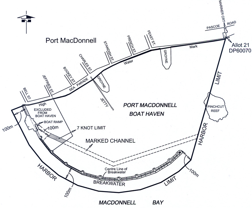
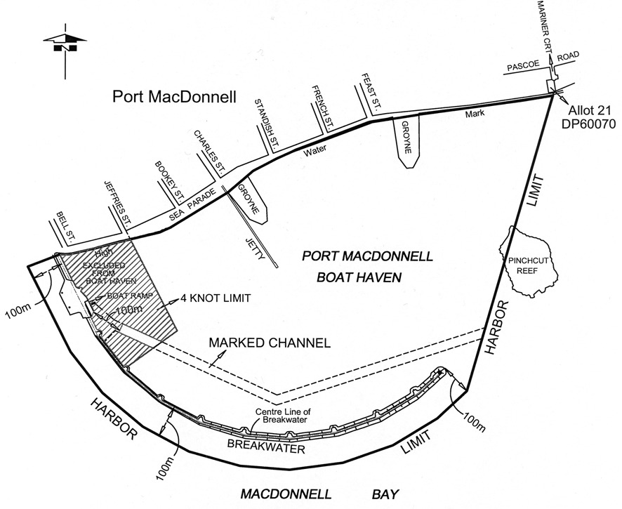
(f) Port
MacDonnell
The waters of Port MacDonnell in that part of the marked channel that is
outside the Port MacDonnell Boat Haven and more than 100 m from the
boat ramp.
(g) Port
Pirie
The portion of the Port Pirie River which lies to the southward of a line
drawn east-north-east and west-south-west through No 11 Side Channel Beacon,
at such times as a signal in the form of a drum shape with black and yellow
vertical stripes or a flashing light of amber colour is displayed from the
stobie pole adjacent to the watch officer's office at No 4 berth during the
hours of daylight and darkness respectively;
(h)
Thevenard
The area bounded as follows:
commencing at a point being the intersection of the High Water Mark and a line
200 m from and parallel to the southern face of the jetty, then approximately
south-westerly along that line to its intersection with a line at right angles
to it and 200 m distant to seaward at its nearest point to the seaward end of
the jetty, then approximately northerly along the latter line to its
intersection with a line being the production seawards of the north boundary
of HB Block 1, then approximately easterly along that produced line to the
High Water Mark, then approximately southerly along the High Water Mark to the
point of commencement;
(i)
Wallaroo
The area bounded as follows:
commencing at the north-western corner of lot 242, town of Wallaroo, then
generally north-westerly to the intersection with a line 150 m from and
parallel to the southern face of the shipping pier, then north-westerly along
the latter line to a point opposite the seaward end of the shipping pier, then
north-westerly a further 120 m on the production north-westerly of the latter
line, then north-easterly along a line at right angles to the latter line to
its intersection with a line 150 m from and parallel to the northern face
of the new shipping pier, then south-easterly along the latter line to its
intersection with the High Water Mark, then generally south-westerly along the
High Water Mark to its intersection with the northern boundary of lots 261 and
262, then westerly along the latter boundary to the western corner of lot 261,
then south-westerly along the north-western boundary of lot 260, then
south-easterly along the south-western boundary of lot 260 to the High Water
Mark, then generally north-westerly, westerly, south-westerly and westerly
along the High Water Mark to its intersection with the south-western boundary
of lot 252, then north-westerly along that boundary to the western corner of
lot 252, then generally south-westerly along the north-western boundaries
of lots 251, 250, Reserve, 248, 247, 246, 245, 244, 243 and 242 to the
point of commencement;
(j)
Whyalla
The area bounded as follows:
commencing at the intersection of the High Water Mark and the production
westerly of the face of the wharf on the north side of the Inner Harbor, then
along the face of that wharf to its seaward end, then approximately
south-easterly to the entrance beacon, then approximately southerly to a light
beacon being the central of 3 beacons marking the northern side of the No 2
Ore Channel, then approximately south-easterly to the light beacon marking the
northern side of the seaward end of that channel, then at an angle of 90°
bearing approximately south-westerly for 140 m then bearing approximately
north-westerly to the light beacon marking the inner end of the southern side
of the channel, then approximately south-westerly to a point on the production
of the line of dolphins at No 1 Ore Jetty and 120 m distant from the
south-westerly face of the most south-westerly dolphin, then approximately
north-westerly and parallel to the centre line of the latter jetty, to the
High Water Mark, then along the High Water Mark to the point of commencement.
The speed limit in the following waters is 4 knots:
(a)
Cowell
The portion of the waters of Cowell (Franklin Harbor) bounded by and to the
west of a line commencing at the seaward end of the jetty and extending in a
south-westerly direction to the seaward end of the southern breakwater;
(b)
Kingston
The portion of the waters of Maria Creek seaward of a line 50 m upstream of,
and parallel to, the eastern boundary of the boat ramp, that portion of the
waters of Lacepede Bay in the channel between the northern groyne and the
southern groyne (extending from Maria Creek to a line drawn between the
western most end of the northern groyne and the navigation light at the
western end of the southern groyne) and that portion of the waters of Lacepede
Bay within a 75 m radius of the midpoint of that line;
(c)
Lincoln Cove Marina
The portion of the waters within Lincoln Cove Marina bounded by a line
commencing at the eastern extremity of the northern breakwater and extending
to the starboard land entrance beacon (F1.G), then to the port land entrance
beacon (F1.R), and then to the eastern extremity of the southern breakwater;
(d)
Mannum Waters Marina
All waters that are from time to time within the Mannum Waters Marina (being
the marina comprising a development declared by the Minister under
section 46(1) of the Development Act 1993 to be development to which
that section applies);
Editorial note—
The marina forms part of the Mannum Waters Marina and residential
development—see Gazette 31.03.2005 p719 for the declaration.
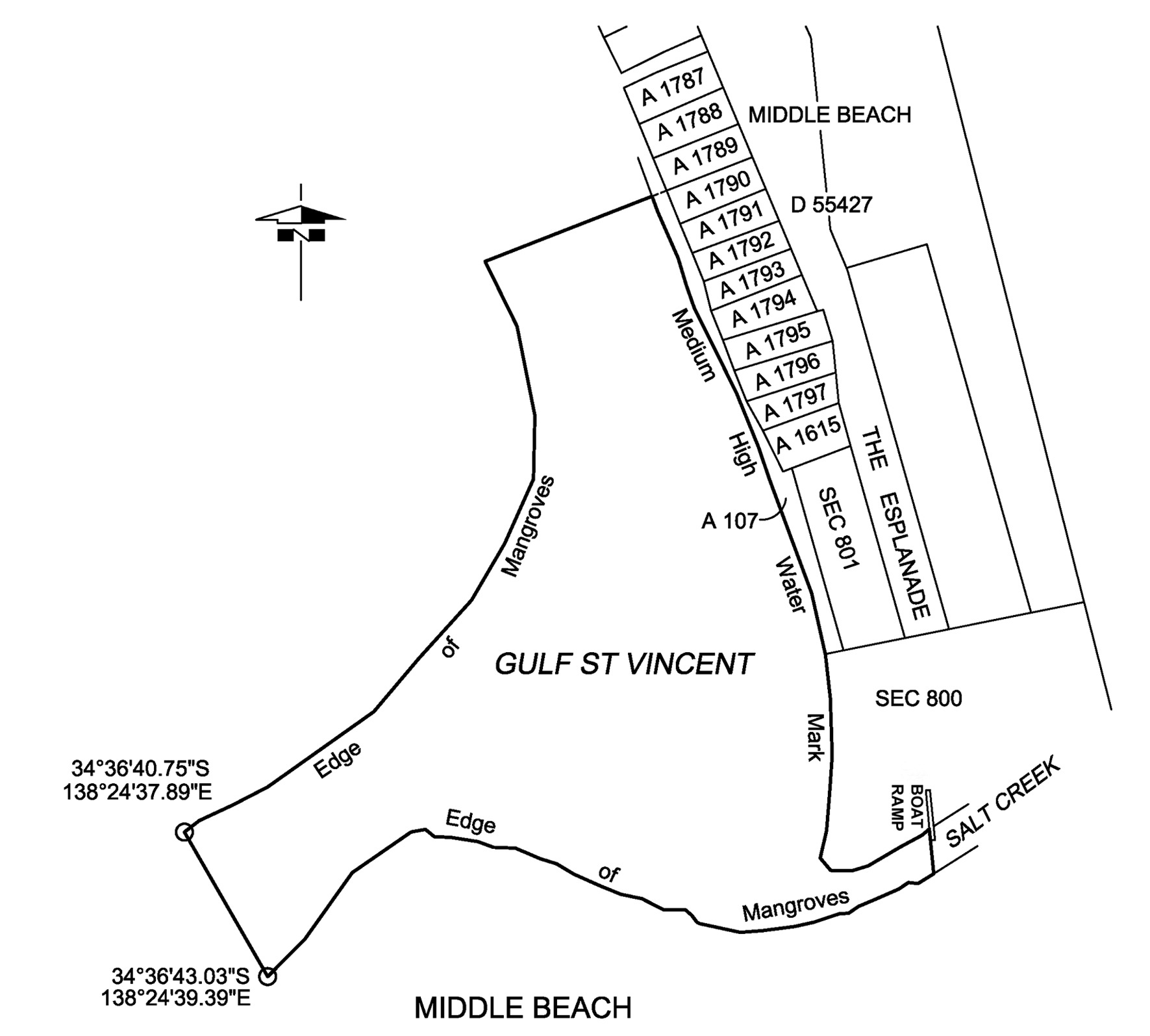
(e)
Middle Beach
The portion of the waters of Gulf St. Vincent bounded as follows:
• commencing at
a point being the intersection of the Medium High Water Mark and the
prolongation generally westerly of the northern boundary of
Allotment 1790 in Deposited Plan No 55427;
• then generally
westerly along that prolongation to the intersection with the edge of
mangroves;
• then generally
southerly and westerly along the edge of mangroves to a point at
34°36′40.75″ South, 138°24′37.89″ East in
WGS84 coordinates;
• then generally
south-easterly along a straight line to a point at
34°36′43.03″ South, 138°24′39.39″ East in
WGS84 coordinates on the edge of mangroves;
• then generally
easterly along the edge of mangroves to the intersection of the prolongation
generally southerly of the western edge of the Middle Beach boat ramp;
• then generally
northerly along the prolongation of the western edge of the boat ramp and
along the western edge of the boat ramp to the intersection with the Medium
High Water Mark;
• then generally
westerly and northerly along the Medium High Water Mark to the point of
commencement.
(f)
Moonta Bay/Port Hughes
The portion of the waters of Spencer Gulf between the prolongation seaward of
the northern boundary of North Terrace, Moonta Bay, and the prolongation
seaward of the southern boundary of the Copper Coast District Council (at
South Beach) and within 200 m seaward of the shoreline;
(g) Port
Adelaide (North Arm)
The portion of the North Arm of the Port Adelaide River bounded by a line
extending generally north and south along the western face of the Wave Screen
at the western end and the Grand Trunkway Bridge at the eastern end;
(h) Port
Adelaide
The area comprising the full width of Port Adelaide River—
(i)
lying abreast of any vessel for the time being moored at
any wharf or any established mooring place together with the area lying
200 m upstream or downstream of that area; or
(ii)
lying abreast of any dredge or marine works in progress
between the Fairway Beacon and Jervois Bridge together with the area lying
200 m upstream or downstream of that area; or
(iii)
lying 100 m upstream or downstream of the Birkenhead
Bridge, a Port River Expressway Bridge or the Jervois Bridge;
(i)
Port MacDonnell
The waters of Port MacDonnell bounded as follows:
• on the
south-east by a line joining the centre of the second turning bay on the
breakwater to the seaward end of the jetty;
• on the
south-west by the centre line of the breakwater;
• on the north
by the High Water Mark;
• on the
north-east by the promulgation seaward of the north-eastern boundary of
Jefferies Street,
but not including the waters in that part of the marked channel that is
outside the Port MacDonnell Boat Haven and more than 100 m from the
boat ramp.
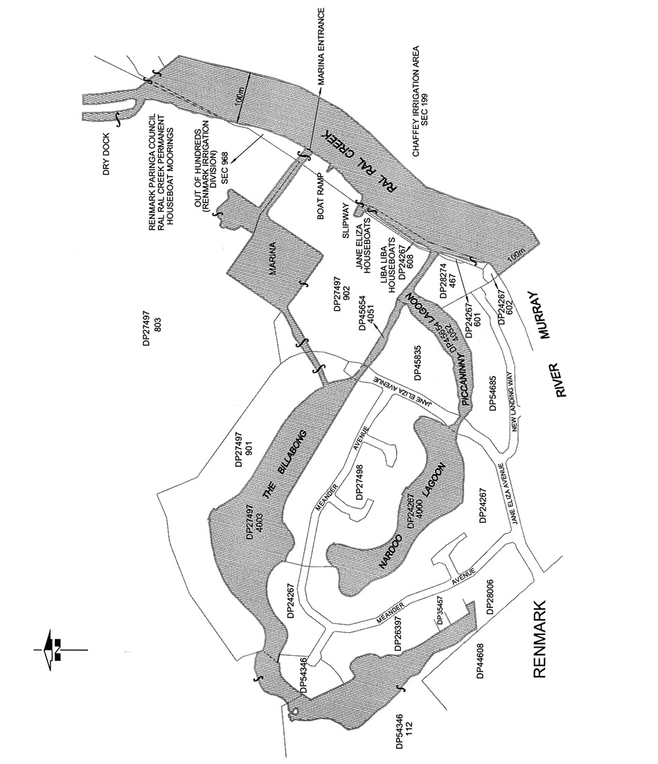
(j)
Renmark
The area comprising—
(i)
the waters of Ral Ral Creek bounded in the north by a
line extending south-east from the south-easternmost corner of the dry dock
and in the south by the prolongation in a generally south-easterly direction
of the south-western boundary of Lot 602 of Deposited Plan No 24267;
and
(ii)
the waters to the east of Ral Ral Creek bounded as
follows:
(A) in the north by a line extending
south-east from the south-easternmost corner of the dry dock referred to in
subparagraph (i);
(B) in the south by the prolongation in a
generally south-easterly direction of the south-western boundary of
Lot 602 of Deposited Plan No 24267;
(C) in the west by Ral Ral Creek;
(D) in the east by a line running parallel
to, at a distance of 100 m from, the western bank of Ral Ral Creek; and
(iii)
the creeks, tributaries, lakes, lagoons or other bodies
of water (collectively known as the Jane Eliza Waterways) connected, whether
directly or indirectly, to the waters described in subparagraph (i);
(k)
Victor Harbor
The portion of the waters of Encounter Bay commencing at the intersection of
the High Water Mark and the base of the north-western edge of the jetty
adjacent to the boat ramp at Rosetta Head, then generally easterly along the
north-western edge of the jetty, then generally north-easterly and easterly
along the starboard hand channel markers of the navigation channel to the
solar light navigation aid at the eastern entrance to the navigation channel,
then generally westerly and south-westerly along the port hand channel markers
of the navigation channel to the southern-most port hand channel marker, then
to a point, on the High Water Mark, 40 m south-east of the point of
commencement, then generally north-westerly along the High Water Mark to the
point of commencement;
(l)
Wallaroo Bay
Area 1 : the portion of the waters of Wallaroo Bay extending to 200 m seaward
from the shoreline, bounded at 1 end by a straight line being the prolongation
seaward of the southern boundary of Phillips Street, Wallaroo and at the other
by the southern breakwater near Copper Cove Marina;
Area 2 : the portion of the waters of Wallaroo Bay extending to 200 m seaward
from the shoreline, bounded at 1 end by the northern breakwater near Copper
Cove Marina and at the other by a straight line extending westerly from the
northern end of Otago Road, North Beach;
Area 3 : the portion of the waters of Wallaroo Bay extending to 200 m seaward
from the shoreline, bounded at 1 end by a straight line being the prolongation
seaward of the southern boundary of Oceanview Drive, North Beach and at the
other by a straight line being the prolongation seaward of the northern
boundary of North Beach Road, North Beach;
(m) West
Beach
The portion of the sea along the metropolitan foreshore within the Adelaide
Shores boat ramp facility at West Beach bounded as follows:
• on the south
and west by the Adelaide Shores boat ramp and rigging area and the adjoining
breakwater;
• on the north
by the northern breakwater;
• on the east by
the High Water Mark;
• on the
north-west by a straight line across the entrance to the Adelaide Shores boat
ramp facility joining the northern end of the western breakwater and the
western end of the northern breakwater;
(n) Port
Broughton
The area bounded as follows:
commencing at the stick beacon without a top-mark situated approximately 655 m
north-north-west of the centre of sea-end of the Port Broughton Jetty and
between stick beacons No's 34 and 35 which are both surmounted by black
triangles (the 3 beacons are on the western side of the Port Broughton
channel) then due east to the High Water Mark on the eastern side of Mundoora
Arm, then generally southerly along the High Water Mark to its intersection
with the production westerly of the southern side of Edmund Street, then
west-north-westerly on a line parallel to the jetty to intersect the High
Water Mark on the western side of the Mundoora Arm, then generally
north-easterly, easterly, south-easterly, north-easterly and north-westerly
along the High Water Mark to a point due west of the point of commencement
then due east to the point of commencement;
(o)
Edithburgh Harbor
The waters within the Edithburgh boating facility bounded by the northern and
southern breakwaters and the waters within a 100 m radius of the centrepoint
of the eastern end of the southern breakwater.
3—4 knot limit—personal watercraft
The speed limit applicable to personal watercraft in the following waters is 4
knots:
(a)
Beachport
The portion of the waters of Rivoli Bay, Beachport, between a straight line
extending easterly from the eastern extremity of Section 467, Hundred of
Rivoli Bay, and the prolongation, south-easterly, of the western boundary of
Section 465, Hundred of Rivoli Bay, and within 100 m seaward of the High Water
Mark;
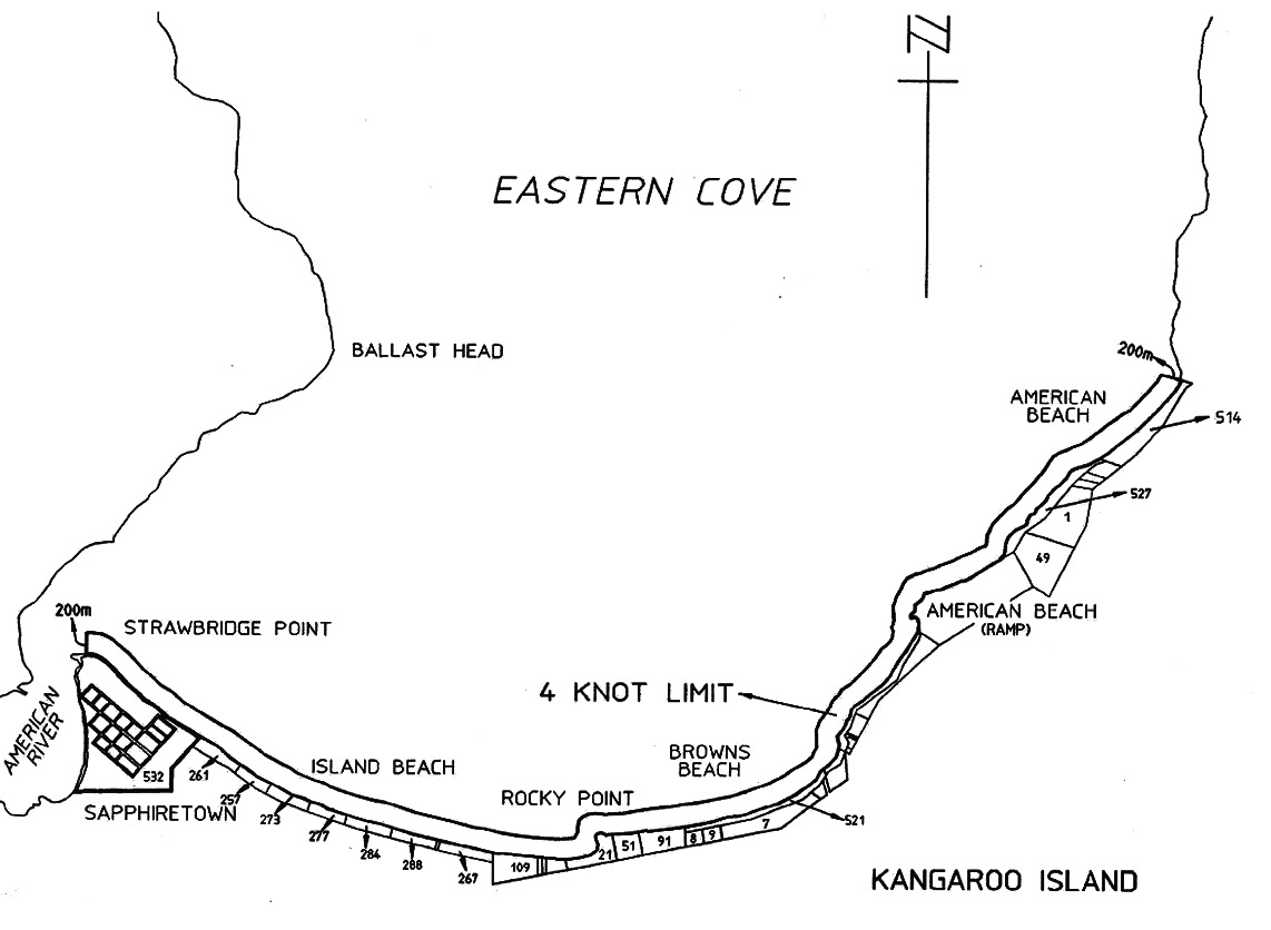
(b)
Kangaroo Island
The portion of the waters of Eastern Cove, Kangaroo Island, between a straight
line extending northerly from the northern extremity of Strawbridge Point and
the prolongation, westerly, of the northern boundary of Section 514,
Hundred of Dudley, and within 200 m seaward of the High Water Mark;
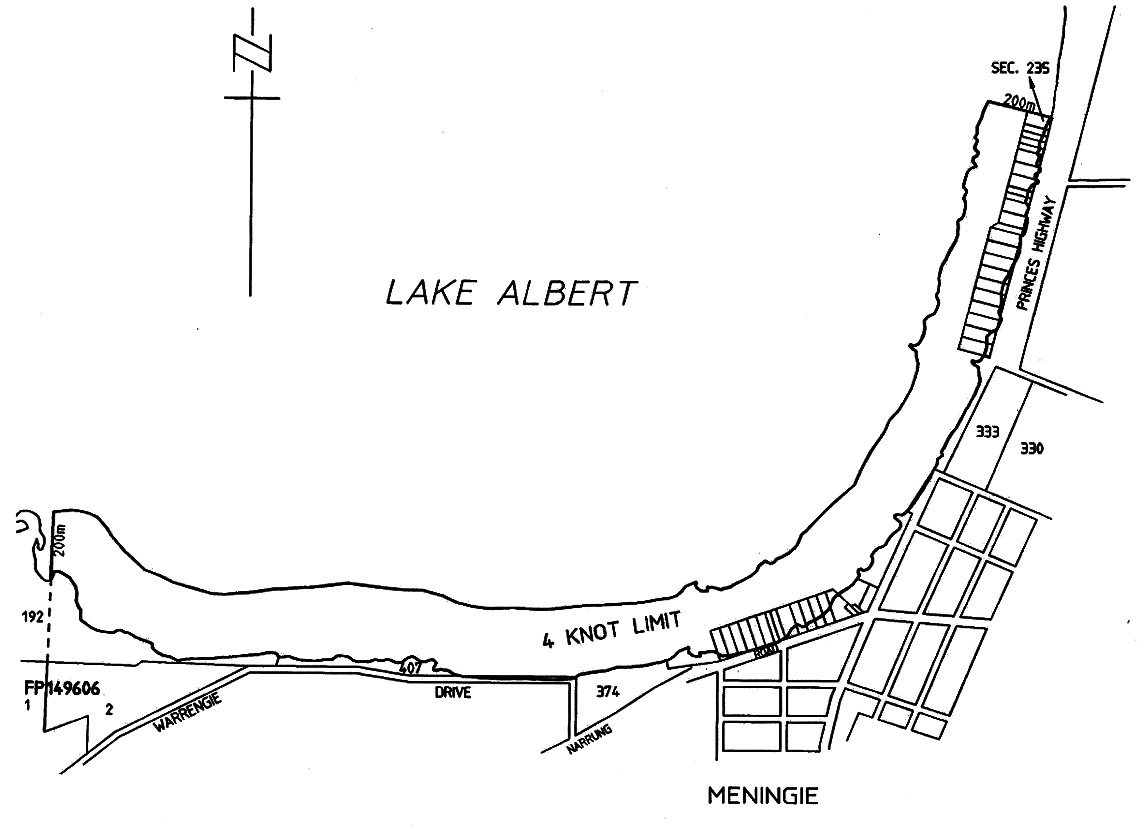
(c)
Meningie
The portion of the waters of Lake Albert, Meningie, between the prolongation,
northerly, of the far western boundary of Allotment 2 in Filed Plan 149606 and
the prolongation, westerly, of the northern boundary of Section 235, Hundred
of Bonney, and within 200 m of the shoreline;
(d)
Metropolitan Foreshore
The portion of the sea along the metropolitan foreshore from the landward end
of the southern breakwater of the Outer Harbor to the southern end of Sellicks
Beach and 200 m seaward of the shoreline;
(e)
River Murray
All creeks, tributaries, lakes, lagoons and other bodies of water connected to
the River Murray between the border of South Australia and a line joining the
upstream sides of the landings used by the ferry at Wellington, except a body
of water that has been exempted by the CE by notice in the Gazette;
(f)
Southend
The portion of the waters of Rivoli Bay, Southend, between the prolongation,
north-easterly, of the northern boundary of Section 372, Hundred of Rivoli
Bay, and the prolongation, north-westerly, of the north-east boundary of
Section 108, Hundred of Rivoli Bay, and within 100 m seaward of the High Water
Mark;
(g)
Victor Harbor
The following areas:
(i)
the portion of the waters of the sea within 200 m of the
centre line of the Granite Island causeway;
(ii)
the portion of the waters of the sea within 200 m of the
High Water Mark of Granite Island, Seal Island, Wright Island or West Island;
(iii)
the portion of the waters of the sea within 200 m of the
High Water Mark of the mainland coastline within the area of the City of
Victor Harbor, being waters within the area bounded—
(A) on the east by the prolongation,
generally south and to seaward, of the easterly boundary of the area of the
City of Victor Harbor (ie the eastern side of Ocean Road, Port Elliot); and
(B) on the west by a line joining the most
southerly point of King Head to the most southerly point of West Island.